


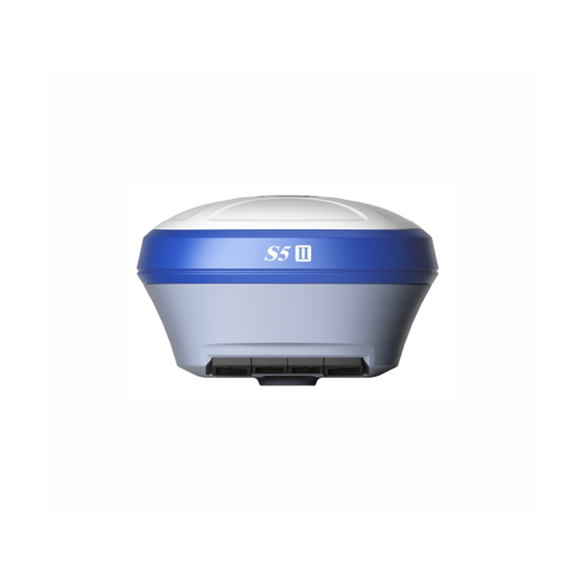


Stonex S9ii/s900 Gnss rtk System Stonex S9 Stonex S9ii Trimble 990 Mainboard Gps Rtk
Product Features
L’S900+ funziona perfettamente con il nostro software da campo Cube-a.
MULTI-CONSTELLAZIONE
Stonex S900+ con i suoi 1408 canali, garantisce una eccellente soluzione di navigazione in tempo reale con alto grado di accuratezza. Tutti i segnali GNSS (GPS, GLONASS, BEIDOU, GALILEO e QZSS) sono inclusi, senza costi aggiuntivi.
TECNOLOGIA IMU
Su S900+ è disponibile la tecnologia IMU che permette un’inizializzazione rapida. L’operatore è in grado di eseguire un rilievo preciso e veloce.
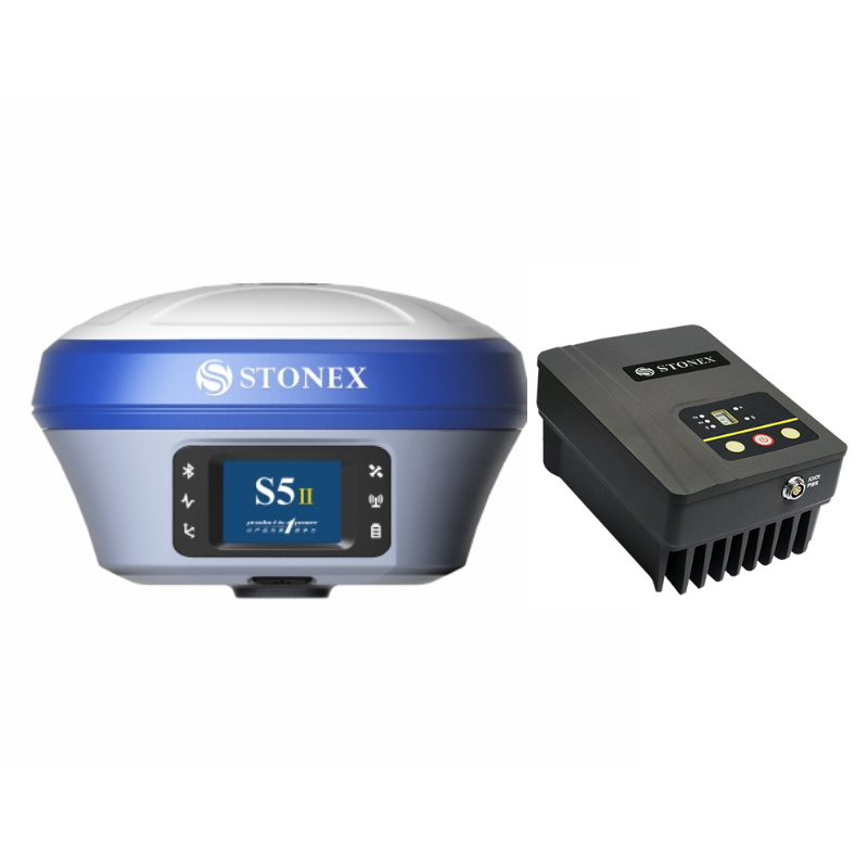
RADIO (opzionale)
Su richiesta è possibile attivare la radio UHF integrata a frequenza 410-470MHz.
MODEM 4G
S900+ ha un modem 4G interno che funziona con tutti i segnali del mondo, è quindi garantita una connessione Internet veloce.
VERSIONE ITALIANA
Se cerchi uno strumento italiano con 3 anni di garanzia, puoi acquistare la versione italiana del nostro ricevitore GNSS S900+.
BATTERIE INTELLIGENTI
Il doppio slot per due batterie Smart hot swap consente di utilizzare l’S900+ fino a 12 ore consecutive. Il livello di batteria può essere controllato e visualizzato sul controller o direttamente sulla barra a led della batteria.
Technical Performance
I. Technical Performance
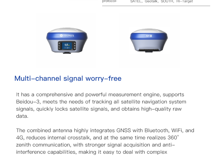
High-precision Measurement:
The Stonex S5II/S990A employs advanced measurement technology to achieve high-precision measurements. Its static accuracy reaches ±(2.5mm+0.5ppm) RMS for horizontal and ±(5mm+0.5ppm) RMS for vertical; while the RTK accuracy is ±(8mm+1ppm) RMS for horizontal and ±(15mm+1ppm) RMS for vertical. It is equipped with a standard Starlink continued operation function, which maintains centimeter-level accuracy for tens of minutes even when the ground-based data link is disconnected, avoiding delays in measurement and repeated work.
Comprehensive Satellite Navigation Support:
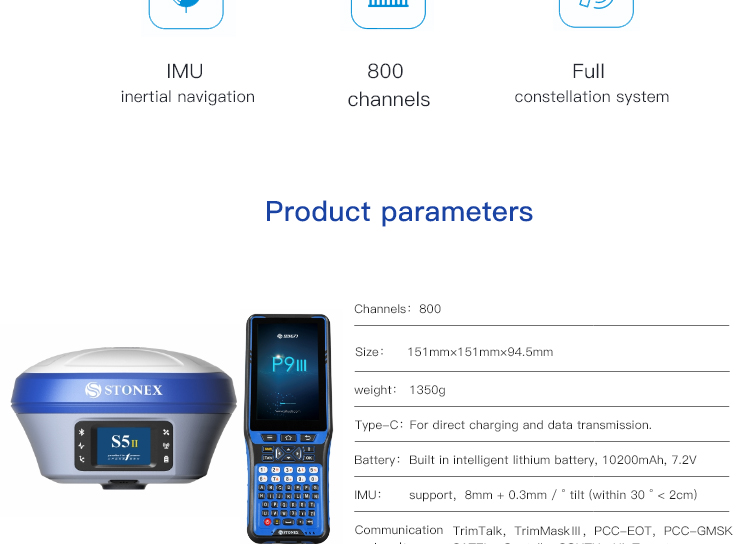
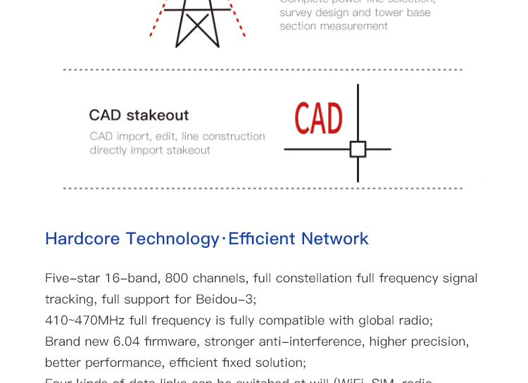
It supports Beidou-3 and other major satellite navigation systems (such as GPS, GLONASS, Galileo, etc.), enabling rapid locking of satellite signals and acquisition of high-quality raw data.
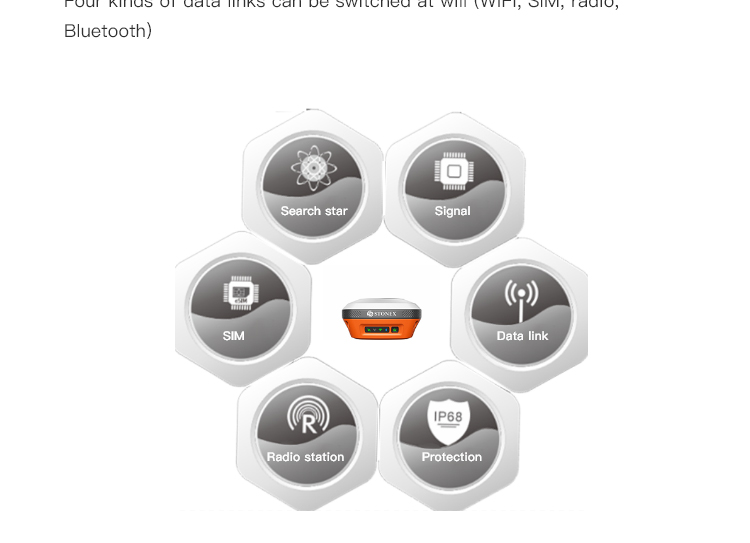
Powerful Communication Capabilities:
Equipped with multiple communication options such as Bluetooth, WiFi, and 4G LTE, it ensures uninterrupted data links. The built-in dual 4G network antennas further enhance data link stability.
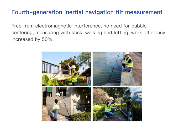
Fourth-generation Inertial Navigation Tilt Measurement Technology:
It eliminates the need for bubble centering, allowing for instant measurements and walking staking simply by carrying the centering pole. With a tilt angle of up to 60° and a data accuracy of 2cm, it significantly improves work efficiency.
II. Operational Convenience
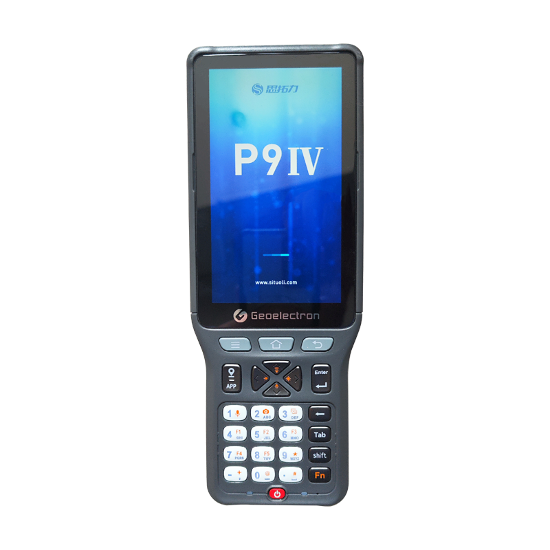
Industrial-grade OLED Color Screen:
Device information remains clearly visible under strong light, and the touch-sensitive settings for configuring the host's working mode are simple, intuitive, and efficient.
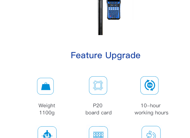
High-capacity Battery and Fast Charging Technology:
It features a built-in 10200mAh high-capacity lithium battery, providing up to 18 hours of operation. Supporting PD fast charging technology, it reduces charging time, and can also be powered by a power bank, ensuring reliable battery life.
Comprehensive Smart Applications:
It supports Stonex Cloud Services, offering synchronized indoor and outdoor operations, real-time map tracking, parameter sharing, remote debugging, and other functions. It also supports cloud data backup, achieving triple backup on the host, handheld device, and cloud service, comprehensively ensuring data security.
III. Durability and Adaptability
Aluminum Frame Space Capsule Design:
The device's structure is sturdy and durable, capable of withstanding various harsh environments.
IP67 Water and Dust Resistance:
It effectively prevents the ingress of dust and water, ensuring normal operation of the device under adverse weather conditions.
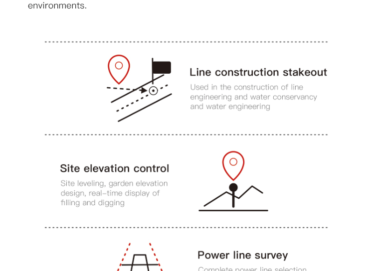
Wide Range of Applications:
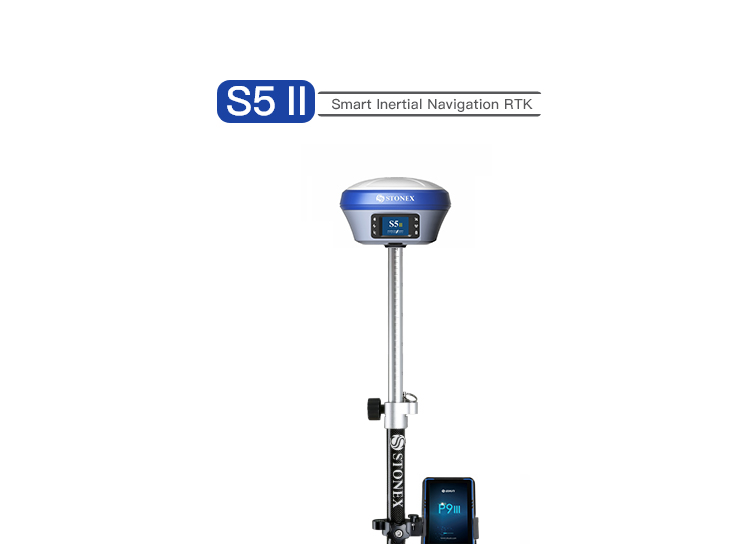
The Stonex S5II/S990A is suitable for various surveying and mapping scenarios, including topographic mapping, property management measurements, engineering staking, and urban planning. Its powerful performance and convenient operation make it a valuable assistant in the surveying and mapping field.
IV. Summary
In summary, the Stonex S5II/S990A is an RTK surveying instrument characterized by high precision, operational convenience, and durability. It has broad application prospects and significant advantages in the surveying and mapping field. Whether considering technical performance, operational convenience, or durability and adaptability, the Stonex S5II/S990A excels in all aspects. Therefore, it is a highly recommended surveying instrument.
Logistics information


Logistics information
Technical Specifications
| GNSS Features | Channels | 800 |
| GPS | L1C/A, L2C, L2P, L5 | |
| GLONASS | L1C/A,L1P,L2C/A,L2P,L3* | |
| BDS | BDS-2: B1I, B2I, B3I BDS-3: B1I, B3I, B1C, B2a, B2b* | |
| GALILEO | E1, E5A, E5B, E6C, AltBOC* | |
| SBAS(WAAS/MSAS/EGNOS/GAGAN) | L1C/A, L5* | |
| IRNSS | L5* | |
| QZSS | L1, L2C, L5* | |
| MSS L-Band | BDS-PPP | |
| Positioning output rate | 1Hz~20Hz | |
| Initialization time | < 10s | |
| Initialization reliability | > 99.99% | |
| Positioning Precision | Code differential GNSS | Horizontal: 0.25 m + 1 ppm RMS Vertical: 0.50 m + 1 ppm RMS |
| Static(long observations) | Horizontal: 2.5 mm + 0.1 ppm RMS Vertical: 3 mm + 0.4 ppm RMS | |
| Static | Horizontal: 2.5 mm + 0.5 ppm RMS Vertical: 3.5 mm + 0.5 ppm RMS | |
| Rapid static | Horizontal: 2.5 mm + 0.5 ppm RMS Vertical: 5 mm + 0.5 ppm RMS | |
| PPK | Horizontal: 3 mm + 1 ppm RMS Vertical: 5 mm + 1 ppm RMS | |
| RTK(UHF) | Horizontal: 8 mm + 1 ppm RMS Vertical: 15 mm + 1 ppm RMS | |
| RTK(NTRIP) | Horizontal: 8 mm + 0.5 ppm RMS Vertical: 15 mm + 0.5 ppm RMS | |
| RTK initialization time | 2-8s | |
| SBAS positioning | Typically < 5m 3DRMS | |
| IMU | Less than 10mm + 0.7 mm/° tilt to 30° | |
| IMU tilt angle | 0° ~ 60° | |
| Hardware Performance | Dimension | 151mmx151mmx94.5mm |
| Weight | 1350g | |
| Material | Magnesium aluminum alloy shell | |
| Operating temperature | -45℃ ~ +65℃ | |
| Storage temperature | -45℃ ~ +85℃ | |
| Humidity | 100% Non-condensing | |
| Waterproof/Dustproof | IP68 standard, protected from long time immersion to depth of 1m | |
| IP68 standard, fully protected against blowing dust | ||
| Shock/Vibration | Withstand 2 meters pole drop onto the cement ground naturally | |
| Power consumption | 2W | |
| Power supply | 6-28V DC, overvoltage protection | |
| Battery | 7.2v 10200mAh | |
| Battery life(Dual-battery) | 15h(Rover Bluetooth mode) | |
| WIFI | Modem | 802.11 b/g standard |
| WIFI hotspot | AP mode, Receiver broadcasts its hotspot form web UI accessing with any mobile terminals | |
| WIFI datalink | Client mode, Receiver can transmit and receive correction data stream via WiFi datalink | |
| Communications | I/O Port | 5-PIN LEMO external power port + RS232 |
| 7-PIN LEMO(USB, OTG and Ethernet) | ||
| 1 PPS data interface | ||
| SIM card slot(standard) | ||
| Internal UHF | Receiver and transmitter 1/2/3W (Just receiver 0.01W for Russia) | |
| Frequency range | 410 - 470MHz | |
| Communication protocol | Farlink, Trimtalk450s, SOUTH, HUACE, ZHD | |
| Communication range | Typically 10km with Farlink protocol | |
| Cellular mobile network | 4G network communication module | |
| Bluetooth | BLEBluetooth 4.0 standard, Bluetooth 2.1 + EDR | |
| NFC Communication | Realizing close range (shorter than 10cm) automatic pair between receiver and controller (controller requires NFC wireless communication module else) | |
| Data Storage/Transmission | Storage | 16GB SSD |
| Automatic cycle storage (The earliest data files will be removed automatically while the memory is not enough) | ||
| Support external USB storage | ||
| Data transmission | Plug and play mode of USB data transmission | |
| Supports FTP/HTTP data download | ||
| Data format | Static data format: STH, Rinex2.01, Rinex3.02, etc. | |
| Differential format: CMR(GPS only), CMR+(GPS only), RTCM 2.3, RTCM 3.0, RTCM 3.1, RTCM 3.2 | ||
| Navigation data format: NMEA 0183, PJK, Binary code | ||
| Network model support: VRS, FKP, MAC, fully support NTRIP protocol | ||
| Sensors | Electronic bubble | Controller software can display electronic bubble, checking leveling status of the carbon pole in real-time |
| IMU | Built-in IMU module, calibration-free and immune to magnetic interference | |
| Thermometer | Built-in thermometer sensor, adopting intelligent temperature control technology, monitoring and adjusting the receiver temperature | |
| User Interaction | Operating system | Linux |
| Buttons | Single button | |
| Indicators | 4 color LED indicators, Battery indicator | |
| Web interaction | With the access of the internal web interface management via WiFi or USB connection, users are able to monitor the receiver status and change the configurations freely | |
| Voice guidance | It provides status and operation voice guidance, and supports Chinese/English/Korean/Spanish/Portuguese/Russian/Turkish | |
| Secondary development | Provides secondary development kit, and opens the OpenSIC observation data format and interaction interface definition | |
| Cloud service | The powerful cloud platform provides online services like remote manage, firmware update, online register and etc. |
Note:
[1]QZSS L6 can be provided by firmware upgrade.
[2]The measurement accuracy, precision, reliability and initialization time depend on various factors, including tilt angle, number of satellites, geometric distribution, observation time, atmospheric conditions and multi-path validation, etc. The data are derived under normal conditions.
[3]Accuracies are dependent on GNSS satellite availability. Hi-Fix Positioning ends after 5 minutes without differential data.Hi-Fix is not available in all regions, check with your local sales representative for more information.
[4]Irregular operations such as rapid rotation and high-intensity vibration may affect the inertial navigation accuracy.
[5]The battery operating time is related to the operating environment, operating temperature and battery life.
Descriptions and Specifications are subject to change without notice