


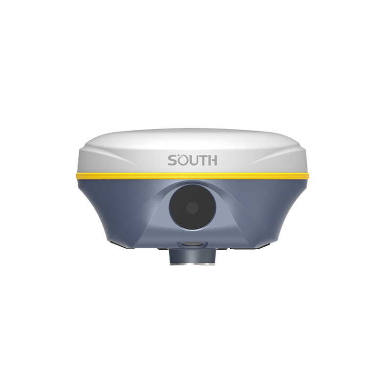
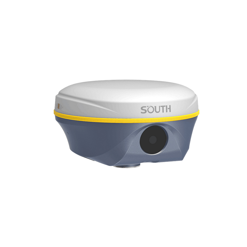
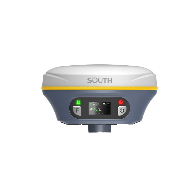

SOUTH Insight V3/S1pro GPS RTK with 1598 Channels and IMU GNSS RTK for Land Surveying Rover And Base Price
Product Features
Real-Scene Dual-Camera RTK: The Southern Fengmang S1 Pro/Insight V3 adopts real-scene dual-camera technology, capable of capturing and recording the actual conditions of the measurement site in real-time, enhancing measurement accuracy and efficiency.
High-Precision Measurement: This product possesses high-precision measurement capabilities, satisfying measurement needs in various complex environments, and ensuring the reliability of measurement results.
Portable Design: The Southern Fengmang S1 Pro/Insight V3 features a portable design, with a compact size and light weight, making it convenient for users to carry and use.
Application Fields
3D Laser Measurement: Suitable for indoor positioning and navigation, precise location services, and other fields, providing users with high-precision 3D laser measurement data.
Deformation Monitoring: In rail transit, construction, and other fields, the Southern Fengmang S1 Pro/Insight V3 can be used for deformation monitoring, promptly identifying and addressing potential safety hazards.
Other Surveying and Mapping Fields: It can also be widely applied in engineering surveying, topographic surveying, geological exploration, and other fields, offering users comprehensive surveying and mapping solutions.
User Feedback
According to user feedback, the Southern Fengmang S1 Pro/Insight V3 excels in measurement accuracy and operational convenience. However, some users have reported that its signal stability needs improvement. This may be related to specific usage environments, operation methods, and other factors. Users should consider their own needs comprehensively when purchasing and using the product.
Price and Cost-Effectiveness
The price of the Southern Fengmang S1 Pro/Insight V3 varies due to factors such as market supply and demand, sales channels, etc. From a cost-effectiveness perspective, the product is equipped with advanced technologies such as high-precision measurement and real-scene dual-camera, and features a portable and easy-to-operate design, providing users with comprehensive surveying and mapping solutions. Therefore, for surveying users requiring high-precision measurement and convenient operation, the Southern Fengmang S1 Pro/Insight V3 offers high cost-effectiveness.
Summary
In summary, the Southern Fengmang S1 Pro/Insight V3 is a surveying and mapping instrument with advanced technologies such as high-precision measurement and real-scene dual-camera. This product is suitable for various surveying and mapping fields, offering users comprehensive solutions. Although some users have concerns about its signal stability, overall, the product still boasts high cost-effectiveness and practicality. Users should consider their own needs comprehensively when purchasing and using the product.
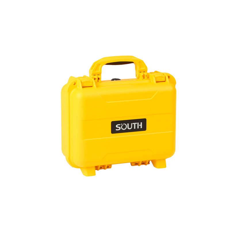
Logistics information


Logistics information
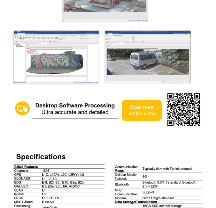
technical parameter
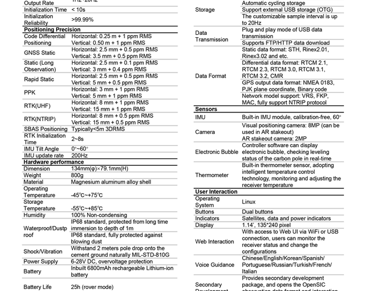
| GNSS Features | Channels | 1698 |
| GPS | L1C/A, L2C, L2P, L5 | |
| GLONASS | L1C/A,L1P,L2C/A,L2P,L3* | |
| BDS | BDS-2: B1I, B2I, B3I BDS-3: B1I, B3I, B1C, B2a, B2b* | |
| GALILEO | E1, E5A, E5B, E6C, AltBOC* | |
| SBAS(WAAS/MSAS/EGNOS/GAGAN) | L1C/A, L5 (Just for the satellites supporting L5) | |
| IRNSS | L5* | |
| QZSS | L1, L2C, L5* | |
| MSS L-Band | BDS-PPP | |
| Positioning output rate | 1Hz~20Hz | |
| Initialization time | < 10s | |
| Initialization reliability | > 99.99% | |
| Positioning Precision | Code differential GNSS | Horizontal: 0.25 m + 1 ppm RMS Vertical: 0.50 m + 1 ppm RMS |
| Static(long observations) | Horizontal: 2.5 mm + 0.1 ppm RMS Vertical: 3 mm + 0.4 ppm RMS | |
| Static | Horizontal: 2.5 mm + 0.5 ppm RMS Vertical: 3.5 mm + 0.5 ppm RMS | |
| Rapid static | Horizontal: 2.5 mm + 0.5 ppm RMS Vertical: 5 mm + 0.5 ppm RMS | |
| PPK | Horizontal: 3 mm + 1 ppm RMS Vertical: 5 mm + 1 ppm RMS | |
| RTK(UHF) | Horizontal: 8 mm + 1 ppm RMS Vertical: 15 mm + 1 ppm RMS | |
| RTK(NTRIP) | Horizontal: 8 mm + 0.5 ppm RMS Vertical: 15 mm + 0.5 ppm RMS | |
| RTK initialization time | < 10s | |
| SBAS positioning | Typically < 5m 3DRMS | |
| IMU | Less than 10mm + 0.7 mm/° tilt to 30° | |
| IMU tilt angle | 0° ~ 60° | |
| Hardware Performance | Dimension | 134mm(φ)× 79.1mm(H) |
| Weight | 800g (battery included) | |
| Material | Magnesium aluminum alloy shell | |
| Operating temperature | -45℃ ~ +65℃ | |
| Storage temperature | -45℃ ~ +85℃ | |
| Humidity | 100% Non-condensing | |
| Waterproof/Dustproof | IP68 standard, protected from long time immersion to depth of 1m | |
| IP68 standard, fully protected against blowing dust | ||
| Shock/Vibration | Withstand 2 meters pole drop onto the cement ground naturally | |
| Power consumption | 4W | |
| Power supply | 6-28V DC, overvoltage protection | |
| Battery | Built-in 7.4 V 6800mAh rechargeable Lithium-ion battery | |
| Battery life(Dual-battery) | 16h (static mode) 10h (internal UHF base mode) 12h (rover mode) | |
| WIFI | Modem | 802.11 b/g standard |
| WIFI hotspot | AP mode, Receiver broadcasts its hotspot form web UI accessing with any mobile terminals | |
| WIFI datalink | Client mode, Receiver can transmit and receive correction data stream via WiFi datalink | |
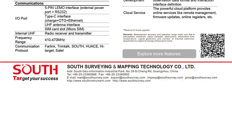
| Communications | I/O Port | 5-PIN LEMO external power port + RS232 |
| 7-PIN LEMO(USB, OTG and Ethernet) | ||
| 1 PPS data interface | ||
| SIM card slot(standard) | ||
| Internal UHF | Receiver and transmitter 1/2/3W (Just receiver 0.01W for Russia) | |
| Frequency range | 410 - 470MHz | |
| Communication protocol | Farlink, Trimtalk450s, SOUTH, HUACE, ZHD | |
| Communication range | Typically 10km with Farlink protocol | |
| Cellular mobile network | 4G network communication module | |
| Bluetooth | BLEBluetooth 4.0 standard, Bluetooth 2.1 + EDR | |
| NFC Communication | Realizing close range (shorter than 10cm) automatic pair between receiver and controller (controller requires NFC wireless communication module else) | |
| Data Storage/Transmission | Storage | 16GB SSD |
| Automatic cycle storage (The earliest data files will be removed automatically while the memory is not enough) | ||
| Support external USB storage | ||
| Data transmission | Plug and play mode of USB data transmission | |
| Supports FTP/HTTP data download | ||
| Data format | Static data format: STH, Rinex2.01, Rinex3.02, etc. | |
| Differential format: CMR(GPS only), CMR+(GPS only), RTCM 2.3, RTCM 3.0, RTCM 3.1, RTCM 3.2 | ||
| Navigation data format: NMEA 0183, PJK, Binary code | ||
| Network model support: VRS, FKP, MAC, fully support NTRIP protocol | ||
| Sensors | Electronic bubble | Controller software can display electronic bubble, checking leveling status of the carbon pole in real-time |
| IMU | Built-in IMU module, calibration-free and immune to magnetic interference | |
| Thermometer | Built-in thermometer sensor, adopting intelligent temperature control technology, monitoring and adjusting the receiver temperature | |
| User Interaction | Operating system | Linux |
| Buttons | Single button | |
| Indicators | 3 color LED indicators, and Battery indicator | |
| Web interaction | With the access of the internal web interface management via WiFi or USB connection, users are able to monitor the receiver status and change the configurations freely | |
| Voice guidance | The intelligent voice technology provides status and operation voice guidance, supports Chinese/English/Korean/Spanish/Portuguese/Russian/Turkish | |
| Secondary development | Provides secondary development kit, and opens the OpenSIC observation data format and interaction interface definition | |
| Cloud service | The powerful cloud platform provides online services like remote manage, firmware update, online register and etc. |