


SOUTH Insight V2/S1 GPS RTK With 1598 Channels and IMU GNSS RTK For Land Surveying Rover And Base Price
SOUTH Insight V2 is a high-performance GNSS RTK (Real-Time Kinematic) receiver, widely used in land surveying, topographic mapping, and other fields. Below is a detailed evaluation of SOUTH Insight V2:
High-Precision Positioning Capability
1.Multi-Frequency and Multi-Satellite System Support: SOUTH Insight V2 supports multiple global satellite navigation systems such as GPS, GLONASS, BDS (BeiDou), and GALILEO, and has multi-frequency reception capabilities, including GPS L1 C/A, L2C, L2P, L5, etc., which enhances positioning accuracy and reliability.
2.High-Precision Positioning Output: In differential GNSS positioning mode, SOUTH Insight V2 achieves a horizontal positioning accuracy of 0.25mm + 1ppm RMS and a vertical positioning accuracy of 0.50mm + 1ppm RMS. Under static observation conditions, its positioning accuracy reaches the millimeter level.
Efficient Data Processing Capability
1. High-Frequency Data Output: SOUTH Insight V2 supports a positioning data output frequency ranging from 1Hz to 20Hz, enabling real-time reflection of target position changes.
2. Rich Data Formats: It supports the output of various data formats, including static data formats such as STH, Rinex2.01, Rinex3.02, and differential data formats such as CMR (GPS only), RTCM 2.x, RTCM 3.x, allowing users to select the appropriate data format based on actual needs.
Convenient Operation and Communication Capability
1. Long Battery Life: Equipped with a 7.4V 6800mAh rechargeable lithium-ion battery, it can continuously operate for 16 hours in static mode, meeting the demands of long-duration measurements.
2. High Protection Level: It features IP68-standard waterproof and dustproof performance, capable of withstanding prolonged immersion in up to 2 meters of water and preventing dust ingress. Additionally, it has shock and drop resistance, enduring impacts from natural falls of up to 2 meters onto concrete surfaces.
Rich Additional Features
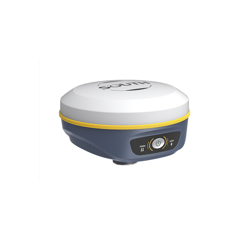
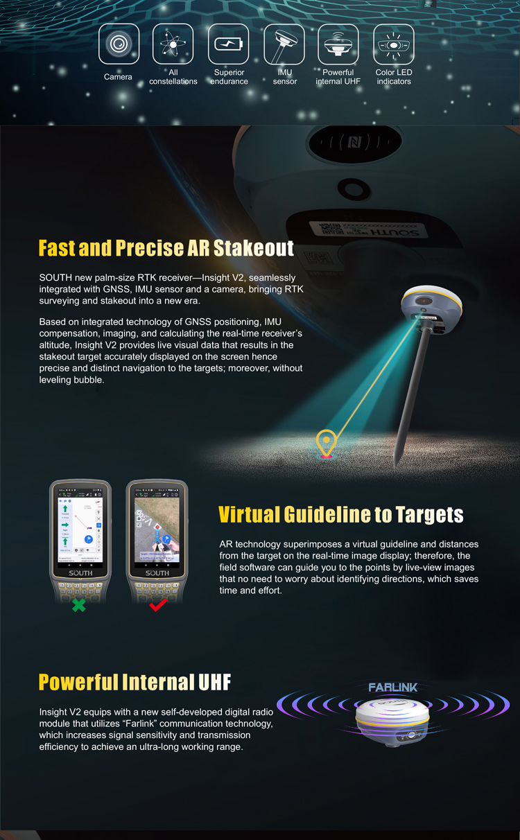
1. Built-in IMU Sensor: SOUTH Insight V2 is equipped with an IMU (Inertial Measurement Unit) sensor, providing additional attitude information such as tilt angles, which helps improve measurement accuracy and stability.
2. Visual Measurement: Some models are equipped with cameras and visual measurement functions, enabling users to have a more intuitive understanding of the measurement site.
In summary, SOUTH Insight V2 demonstrates outstanding performance in land surveying, topographic mapping, and other fields, thanks to its high-precision positioning capability, efficient data processing capability, convenient operation and communication capability, powerful battery life and protection performance, as well as rich additional features. However, specific usage effects may vary depending on the actual application scenario and user needs. It is recommended to fully understand the product performance and user evaluations before purchasing.
Logistics information


Logistics information
technical parameter
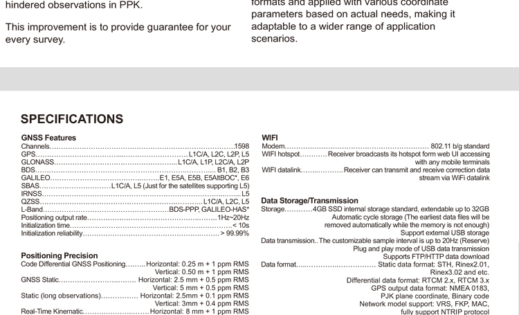
| GNSS Features | Channels | 1598 |
| GPS | L1C/A, L2C, L2P, L5 | |
| GLONASS | L1C/A,L1P,L2C/A,L2P,L3* | |
| BDS | BDS-2: B1I, B2I, B3I BDS-3: B1I, B3I, B1C, B2a, B2b* | |
| GALILEO | E1, E5A, E5B, E6C, AltBOC* | |
| SBAS(WAAS/MSAS/EGNOS/GAGAN) | L1C/A, L5 (Just for the satellites supporting L5) | |
| IRNSS | L5* | |
| QZSS | L1, L2C, L5* | |
| MSS L-Band | BDS-PPP | |
| Positioning output rate | 1Hz~20Hz | |
| Initialization time | < 10s | |
| Initialization reliability | > 99.99% | |
| Positioning Precision | Code differential GNSS | Horizontal: 0.25 m + 1 ppm RMS Vertical: 0.50 m + 1 ppm RMS |
| Static(long observations) | Horizontal: 2.5 mm + 0.1 ppm RMS Vertical: 3 mm + 0.4 ppm RMS | |
| Static | Horizontal: 2.5 mm + 0.5 ppm RMS Vertical: 3.5 mm + 0.5 ppm RMS | |
| Rapid static | Horizontal: 2.5 mm + 0.5 ppm RMS Vertical: 5 mm + 0.5 ppm RMS | |
| PPK | Horizontal: 3 mm + 1 ppm RMS Vertical: 5 mm + 1 ppm RMS | |
| RTK(UHF) | Horizontal: 8 mm + 1 ppm RMS Vertical: 15 mm + 1 ppm RMS | |
| RTK(NTRIP) | Horizontal: 8 mm + 0.5 ppm RMS Vertical: 15 mm + 0.5 ppm RMS | |
| RTK initialization time | < 10s | |
| SBAS positioning | Typically < 5m 3DRMS | |
| IMU | Less than 10mm + 0.7 mm/° tilt to 30° | |
| IMU tilt angle | 0° ~ 60° | |
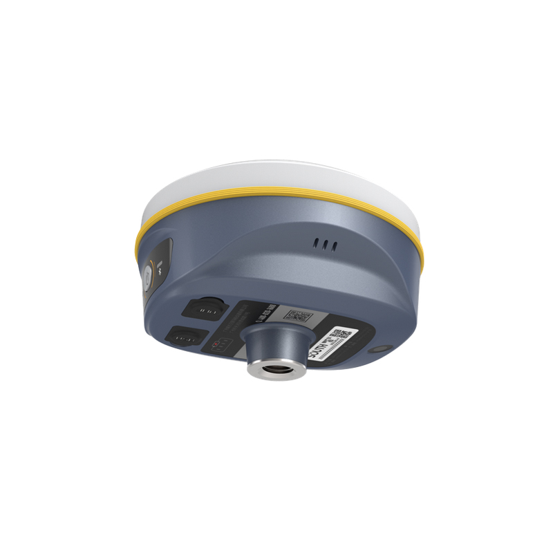
| Hardware Performance | Dimension | 131mm(φ)× 80mm(H) |
| Weight | 800g (battery included) | |
| Material | Magnesium aluminum alloy shell | |
| Operating temperature | -45℃ ~ +65℃ | |
| Storage temperature | -45℃ ~ +85℃ | |
| Humidity | 100% Non-condensing | |
| Waterproof/Dustproof | IP68 standard, protected from long time immersion to depth of 1m | |
| IP68 standard, fully protected against blowing dust | ||
| Shock/Vibration | Withstand 2 meters pole drop onto the cement ground naturally | |
| Power consumption | 4W | |
| Power supply | 6-28V DC, overvoltage protection | |
| Battery | Built-in 7.4 V 6800mAh rechargeable Lithium-ion battery | |
| Battery life(Dual-battery) | 16h (static mode) 10h (internal UHF base mode) 12h (rover mode) | |
| WIFI | Modem | 802.11 b/g standard |
| WIFI hotspot | AP mode, Receiver broadcasts its hotspot form web UI accessing with any mobile terminals | |
| WIFI datalink | Client mode, Receiver can transmit and receive correction data stream via WiFi datalink | |
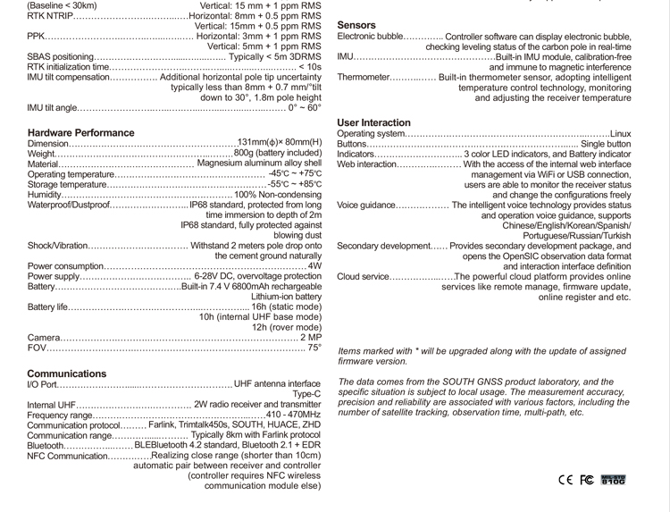
| Communications | I/O Port | 5-PIN LEMO external power port + RS232 |
| 7-PIN LEMO(USB, OTG and Ethernet) | ||
| 1 PPS data interface | ||
| SIM card slot(standard) | ||
| Internal UHF | Receiver and transmitter 1/2/3W (Just receiver 0.01W for Russia) | |
| Frequency range | 410 - 470MHz | |
| Communication protocol | Farlink, Trimtalk450s, SOUTH, HUACE, ZHD | |
| Communication range | Typically 10km with Farlink protocol | |
| Cellular mobile network | 4G network communication module | |
| Bluetooth | BLEBluetooth 4.0 standard, Bluetooth 2.1 + EDR | |
| NFC Communication | Realizing close range (shorter than 10cm) automatic pair between receiver and controller (controller requires NFC wireless communication module else) | |
| Data Storage/Transmission | Storage | 16GB SSD |
| Automatic cycle storage (The earliest data files will be removed automatically while the memory is not enough) | ||
| Support external USB storage | ||
| Data transmission | Plug and play mode of USB data transmission | |
| Supports FTP/HTTP data download | ||
| Data format | Static data format: STH, Rinex2.01, Rinex3.02, etc. | |
| Differential format: CMR(GPS only), CMR+(GPS only), RTCM 2.3, RTCM 3.0, RTCM 3.1, RTCM 3.2 | ||
| Navigation data format: NMEA 0183, PJK, Binary code | ||
| Network model support: VRS, FKP, MAC, fully support NTRIP protocol | ||
| Sensors | Electronic bubble | Controller software can display electronic bubble, checking leveling status of the carbon pole in real-time |
| IMU | Built-in IMU module, calibration-free and immune to magnetic interference | |
| Thermometer | Built-in thermometer sensor, adopting intelligent temperature control technology, monitoring and adjusting the receiver temperature | |
| User Interaction | Operating system | Linux |
| Buttons | Single button | |
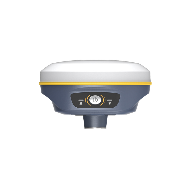
| Indicators | 3 color LED indicators, and Battery indicator | |
| Web interaction | With the access of the internal web interface management via WiFi or USB connection, users are able to monitor the receiver status and change the configurations freely | |
| Voice guidance | The intelligent voice technology provides status and operation voice guidance, supports Chinese/English/Korean/Spanish/Portuguese/Russian/Turkish | |
| Secondary development | Provides secondary development kit, and opens the OpenSIC observation data format and interaction interface definition | |
| Cloud service | The powerful cloud platform provides online services like remote manage, firmware update, online register and etc. |