


LiGrip O1 Lite Rotary Handheld Scanner with HD Camera Rotating Handheld SLAM LiDAR System Scanner
Product Introduction
The following is the English translation of the given text:
I. Product Design and Portability
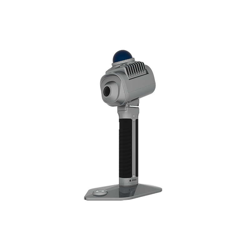
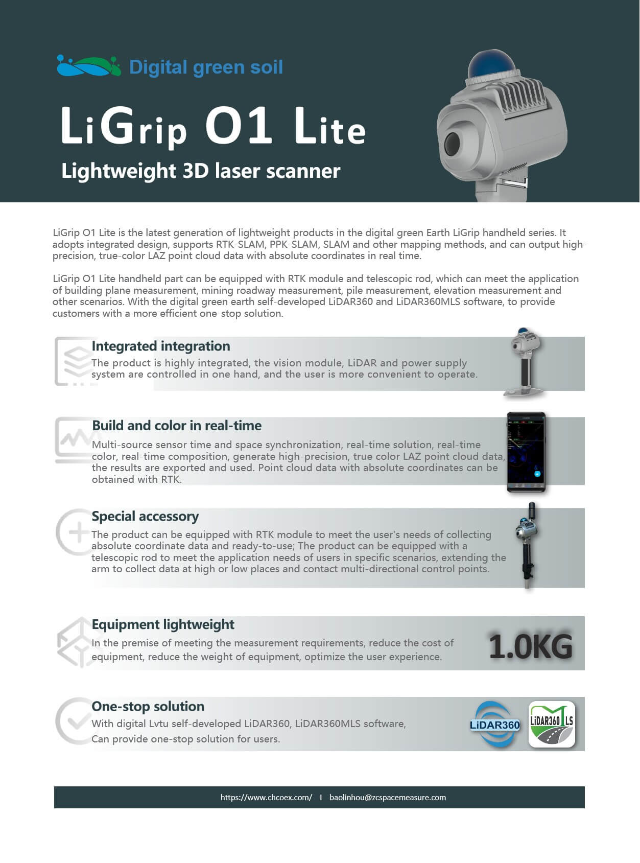
LiGrip O1 Lite, the latest generation of lightweight handheld scanner in Digital Green Earth's LiGrip series, adopts a highly integrated and unified design. This design not only makes the product more compact and lightweight but also greatly enhances user operational convenience. With a pure handheld weight of just 1.0kg (including base and battery) and dimensions of 184mm×115mm×304mm, this size and weight design allows users to hold and operate the device for extended periods without fatigue.
II. Scanning Performance and Accuracy
In terms of scanning performance, LiGrip O1 Lite excels. It supports multiple mapping methods such as RTK-SLAM, PPK-SLAM, and SLAM, capable of outputting high-precision, true-color LAS or LAZ point cloud data in real-time. This data not only boasts high precision but also includes absolute coordinate information, which is of great significance for subsequent data processing and applications. Furthermore, its LiDAR scanning frequency reaches up to 200,000 points per second, with a measurement distance of up to 70m (at 80% reflectivity), and a LiDAR accuracy of 2cm. These parameters ensure efficient and accurate scanning.
III. Expandability and Application Scenarios
The handheld portion of LiGrip O1 Lite can be equipped with an RTK module and an extendable rod, further expanding its application scenarios. The addition of the RTK module allows users to collect data with absolute coordinates, meeting the demand for immediate use upon collection. The extendable rod enables users to extend their reach to collect data from high or low positions in specific scenarios, as well as for contact-based multi-directional control point applications. This makes LiGrip O1 Lite widely applicable in various fields such as building plan measurement, mine tunnel surveying, stockpile measurement, and facade measurement.
IV. Software Support and One-Stop Solutions
Digital Green Earth has equipped LiGrip O1 Lite with its proprietary LiDAR 360 and LiDAR 360 MLS software, providing users with more efficient one-stop solutions. Through these software tools, users can conveniently perform data processing, analysis, and visualization operations, significantly enhancing work efficiency.
V. Other Features
LiGrip O1 Lite also boasts an IP54 protection rating, capable of withstanding a certain amount of dust and moisture ingress, allowing it to operate normally in harsh environments. Additionally, its battery capacity is 3450mAh, providing a runtime of up to 180 minutes, ensuring long-term operational needs. Furthermore, the product supports OTA/offline firmware upgrades, enabling users to easily access the latest features and performance optimizations.
In summary, Digital Green Earth's newly released LiGrip O1 Lite handheld scanner excels in product design, scanning performance, expandability, software support, and other features. It not only meets measurement needs in various complex scenarios but also provides users with efficient and convenient one-stop solutions. Therefore, LiGrip O1 Lite is undoubtedly a high-performance handheld scanner worth recommending.
Product Features
The detailed parameters of the LiGrip O1 Lite handheld scanner from Digital Green Soil are as follows:
I. Basic Parameters
●Product Dimensions: 184mm x 115mm x 304mm
●Pure Handheld Weight: 1.0kg (including base and battery)
●Battery Capacity: 3450mAh (some sources indicate 3350mAh, but the latest or official data should prevail)
●Voltage: 14.4V
●TF Storage Capacity: 256GB (standard), supports up to 1TB expansion
●Port: TypeC
●Control Method: APP/Button
●Firmware Upgrade: OTA/Offline
●Protection Level: IP54
●Battery Life: 180 minutes
●Operating Temperature: -20℃ to 40℃
●Device Storage Temperature: -40℃ to 70℃
●Battery Storage Temperature: Recommended storage temperature is 22℃ to 30℃
II. LiDAR Parameters
●Laser Type: Mid 360
●Laser Wavelength: 905nm
●Scanning Frequency: 200,000 points/second (some sources indicate 20W points/second, but 20W usually refers to power, so 200,000 points/second is more accurate)
●Measurement Distance: 40m (at 10% reflectivity); 70m (at 80% reflectivity)
●LiDAR Accuracy: 2cm
●Scanning Field of View: Horizontal 360°, Vertical -7° to 52°
III. Camera Parameters
●Camera Type: LiCam
●Resolution: 3840 x 2160
●Field of View: 240° x 143°
●Image Format: bin (before parsing)/JPG (after parsing)
●Shooting Frame Rate: 0 to 5 frames/second (adjustable)
IV. Mapping Methods
●Mapping Principle: Supports RTK-SLAM, PPK-SLAM, and pure SLAM real-time calculation
●Real-time Colorization: Supported
V. Data Outcomes
●Relative Accuracy: ≤2cm
●Absolute Accuracy: ≤5cm
●Point Cloud Format: LAZ (real-time processing), LiData (post-processing)
VI. Optional Accessory Parameters (RTK Module)
●Satellite Systems Supported: 5 constellations, 14 frequencies, including GPS (L1/L2/L5), GLO (L1/L2), BDS (B1I/B2I/B3I), GAL (E1/E5a/E5b), QZSS (L1/L2/L5)
●RTK Accuracy: Plane 0.8cm + 1ppm; Elevation 1.5cm + 1ppm
●RTK Data Format: rtk
●RTK Protocol: NTRIP protocol
●Network Communication: 4G global access
●Dimensions: 45mm x 45mm x 95mm
●Weight: 119g
●GNSS Raw Data Format: log
VII. Other Features
●Can be equipped with an RTK module and telescoping pole to expand application scenarios.
●Equipped with external and built-in electronic spirit levels to improve measurement accuracy.
●Supports multiple mapping methods to meet different needs.
●High-precision, true-color point cloud data output facilitates subsequent processing.
In summary, the LiGrip O1 Lite handheld scanner excels in terms of parameters, featuring high precision, high efficiency, and multifunctionality, making it suitable for various measurement scenarios and requirements.
Logistics information


Logistics information