


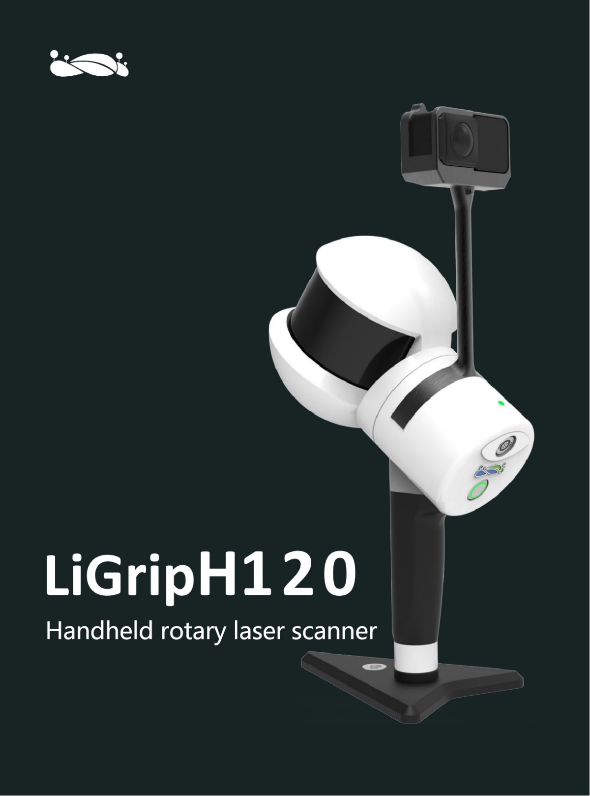
LiGrip H120 SLAM Handheld Laser Lidar Scanning 3D Scanner for Survey Equipment Engineering Scanner
Product Introduction
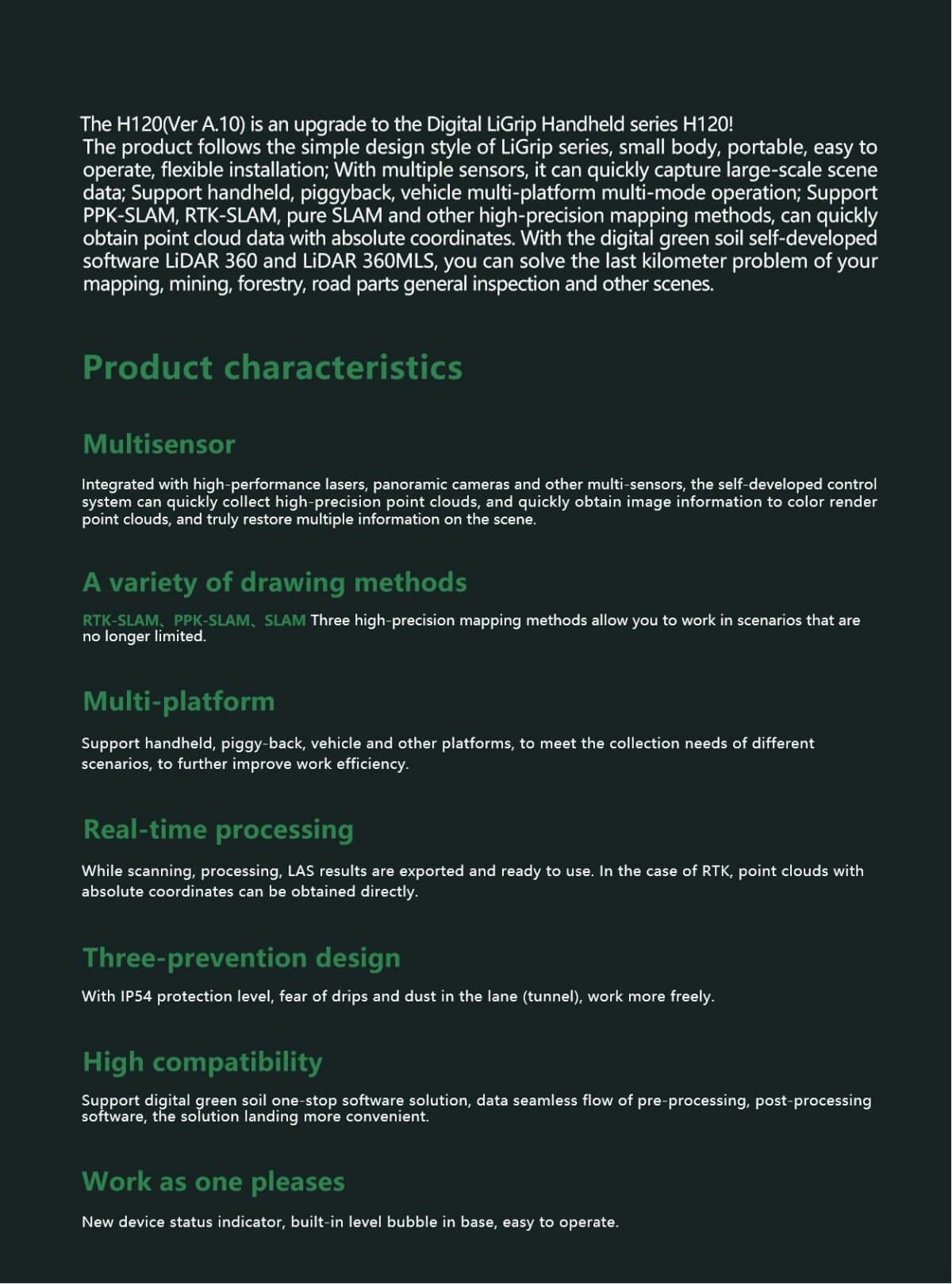
The LiGrip H120 handheld scanner from Digital Green Soil is a device with excellent performance and comprehensive functions. Here is a detailed evaluation of the device:
I. Design and Portability
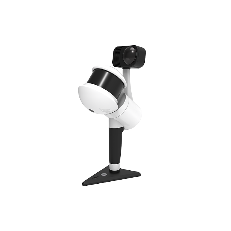
The LiGrip H120 handheld scanner adopts a minimalist design style, with a compact and lightweight body that is easy to hold and operate. The installation is also very flexible. This design allows users to easily carry and operate the device, making it suitable for various outdoor and indoor scenarios.
II. High Precision and Multi-sensor Integration
1.High Precision: The LiGrip H120 is equipped with a high-performance LiDAR sensor, capable of achieving high-precision 3D scanning. Its LiDAR accuracy can reach 1cm, with a scanning frequency of up to 320,000 points per second and a measurement distance of up to 120 meters, ensuring the accuracy and completeness of the scanned data.
2.Multi-sensor Integration: In addition to the LiDAR sensor, the LiGrip H120 also integrates multiple high-performance sensors such as a panoramic camera. These sensors can simultaneously collect high-precision point cloud and image information, and perform color rendering on the point cloud, thereby accurately reflecting multiple information of the acquisition scene.
III. Multi-platform and Multi-mode Operation
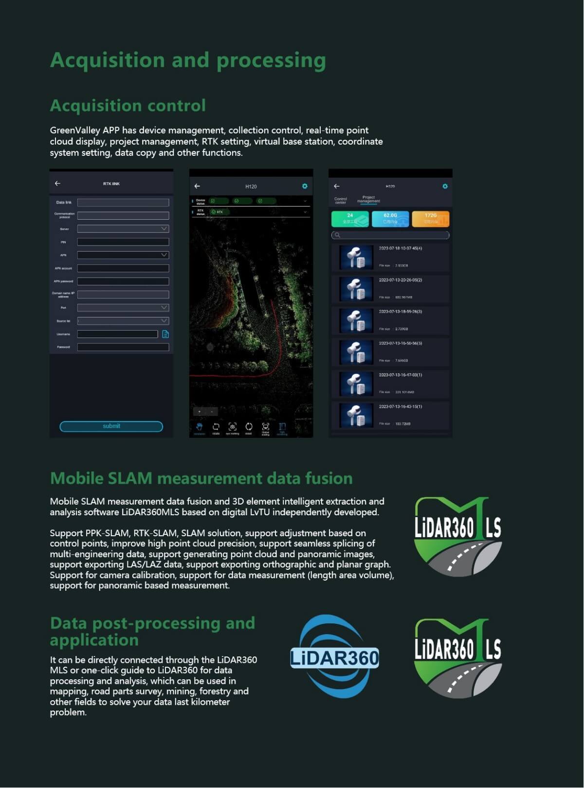
The LiGrip H120 supports various platforms such as handheld, backpack, and vehicle-mounted operations, meeting the acquisition needs of different scenarios. At the same time, it also supports multiple high-precision mapping methods such as PPK-SLAM, RTK-SLAM, and pure SLAM, enabling rapid acquisition of point cloud data with absolute coordinates. This multi-platform and multi-mode operation greatly improves the applicability and flexibility of the device.
IV. Data Processing and Compatibility
1.Real-time Processing: The LiGrip H120 supports data processing while scanning, with LAS results ready for use upon export. In the presence of RTK, point cloud data with absolute coordinates can be directly obtained, greatly improving work efficiency.
2.High Compatibility: The device supports Digital Green Soil's one-stop software solution, allowing seamless data flow to preprocessing and post-processing software, making the solution implementation more convenient. At the same time, it is compatible with multiple data formats and storage devices, facilitating data management and sharing for users.
V. Durability and Protection Level
The LiGrip H120 has an IP54 protection level, fearless of water drips and dust in tunnels, and can maintain stable operation in harsh working environments. This durability ensures the reliability and stability of the device in various complex scenarios.
VI. Wide Range of Applications
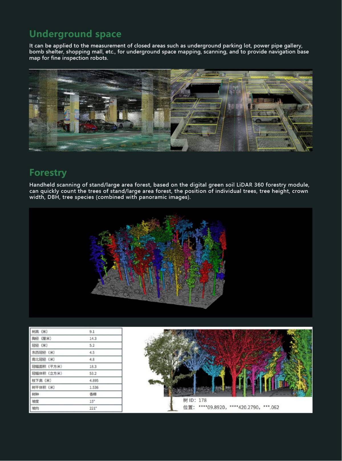
The LiGrip H120 handheld scanner is widely used in fields such as surveying and mapping, mining, forestry, and road component inventory. It can quickly capture large-scale scene data, providing efficient and accurate 3D scanning solutions for these fields.
In summary, the LiGrip H120 handheld scanner from Digital Green Soil is a device with excellent performance, comprehensive functions, portability, ease of use, and durability. It can meet the 3D scanning needs of various complex scenarios and provide efficient and accurate data support for related fields.
Product Features
The detailed parameters of the LiGrip H120 handheld scanner from Digital Green Soil are as follows:
I. Basic Physical Parameters
●Handheld Size: 204mm×130mm×385mm
●Battery Box Size: 134mm×64.6mm×167mm
●Handheld Weight: 1.83kg (including the marking base and camera), alternatively stated as 1.74kg
●Material: Aluminum alloy + carbon fiber (this may apply to the backpack version; the handheld version is not explicitly mentioned but presumed to contain lightweight materials)
II. Performance Parameters
●Scanning Frequency: 320,000 points/second
●Measurement Distance: 120m
●LiDAR Accuracy: 1cm (alternatively stated as ±3cm, which may vary depending on specific application scenarios and measurement conditions)
●Scanning Field of View: 280°×360°
●Relative Accuracy: ≤1cm (under standard precision conditions and with strict operational norms)
●Absolute Accuracy: ≤5cm
III. Battery and Power Parameters
●Battery Capacity: 5870mAh
●Single Battery Operating Time: 240 minutes (i.e., 4 hours)
●Maximum Continuous Scanning Time: 55 minutes (may be affected by various factors such as scanning frequency and ambient brightness)
●Voltage: 15.2V
IV. Storage and Data Parameters
●Storage Space: 256GB SSD
●Data Formats: Point cloud formats include LAZ, LiData, etc.; video data format is MP4 INSV; photo resolution is 6080×3040 (2:1); video resolution is 5760×2880 @ 30 fps
●Data Export: Supports LAS format export, ready for use
V. Interfaces and Connectivity
●Ports: USB, Ethernet
●Camera Parameters: 360° panoramic lens combination, CMOS sensor type
●RTK Module: Supports GPS+BDS+Glonass+Galileo+QZSS, 5 constellations and 16 frequencies, RTK accuracy is 1cm+1ppm, RTK data format is .rtk, GNSS raw data format is .log
VI. Environmental and Compatibility Parameters
●Applicable Environments: Suitable for both indoor and outdoor scenarios
●Protection Level: IP54, resistant to water drips and dust in tunnel environments
●Compatibility: Supports Digital Green Soil's one-stop software solution, with seamless data flow for preprocessing and post-processing software; compatible with LiDAR parameters of H300, H120, etc.
VII. Other Parameters
●Device Storage Temperature: -40℃ to 70℃
●Battery Storage Temperature: Recommended storage temperature is 22℃ to 30℃; storage time is limited under other temperature conditions, such as less than 1 month at 20℃ to 50℃, and less than 3 months at -20℃ to 40℃
●Software Support: Compatible with Digital Green Soil's self-developed software LiDAR 360 and LiDAR 360MLS
In summary, the LiGrip H120 handheld scanner features high precision, high scanning speed, multi-sensor integration, long operating time, large storage capacity, good environmental adaptability, and high compatibility, making it suitable for various applications such as surveying and mapping, mining, forestry, and road component inventory.
Logistics information


Logistics information