


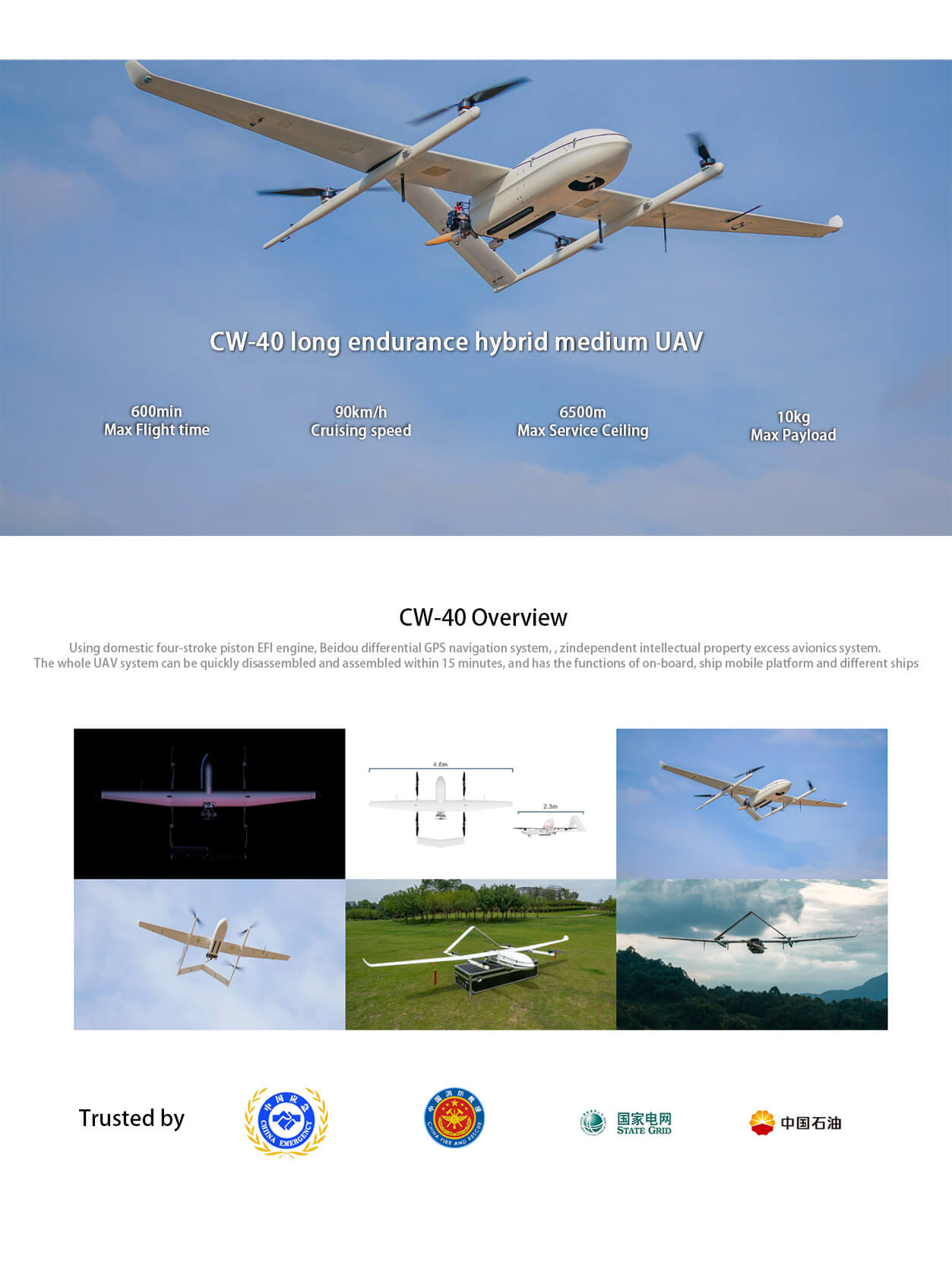
JOU CW-40 long-duration hybrid medium-sized drone
Product Introduction
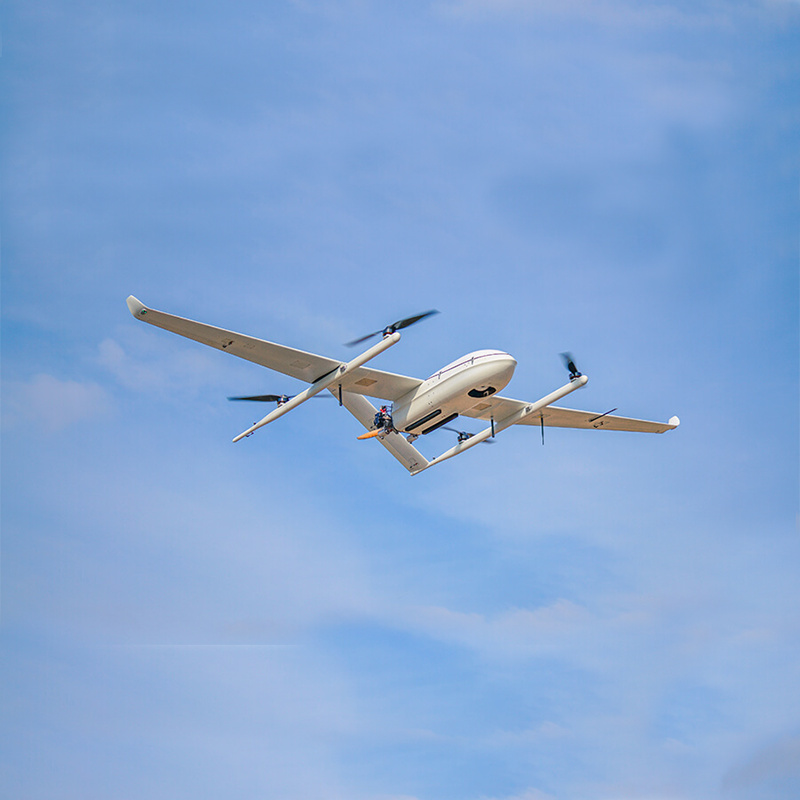
The JOUAV CW-40 UAV is the 1 outstanding and full-featured UAV system. The following is a detailed evaluation of it:
Excellent 1. performance
Power system: CW-40 UAV is equipped with a domestic parallel bars four-stroke EFI engine with independent intellectual property rights, which has the characteristics of low vibration, low fuel consumption, low noise and long life, and meets the needs of gasoline and heavy oil.
Endurance: The maximum load can reach 10kg, the longest endurance can reach 10 hours, the range can reach 900km, and the effective control radius can reach 200km. It is suitable for large-area and long-distance video surveillance scenes.
Flight performance: the service ceiling is 6500m, the maximum take-off altitude is 4000m, and the wind resistance is 13.9-17.1 m/s, which ensures the stable flight of the UAV in various complex environments.
Full-featured 2.
High-precision positioning: The Beidou double differential direction finding and navigation module is used to provide high-precision positioning; with anti-jamming GPS technology, it can effectively resist the influence of complex electromagnetic environment.
Data security: The data hard encryption function guarantees information security and ensures the security of data transmission and storage.
Multiple relay modes: Support air-to-air, ground-to-air, broadcast and other relay modes to meet the communication needs in different scenarios.
Mobile take-off and landing function: it has the powerful function of taking off and landing on the vehicle, ship mobile platform and taking off and landing of different ships in different places, which improves the flexibility and applicability of the UAV.
Flexible 3. configuration
Strong scalability: sufficient cabin space, rich electrical interface, support a variety of task load mounting, such as high-performance three-light photoelectric pod.
Various configurations: supports application scenarios such as single-station single-machine, single-station multi-machine, and single-machine multi-station to meet the diverse needs of different users.
4. widely used
Border inspection: by carrying high-performance task sensors, real-time monitoring and inspection of border areas are realized.
Shoreline inspection: the use of long-term and high-precision positioning capabilities, the coastline for efficient inspection.
Security monitoring: suitable for urban security, traffic monitoring and other scenarios, to provide real-time, high-definition video surveillance services.
Emergency response: Provide rapid response and on-site monitoring services in emergency scenarios such as natural disasters and emergencies.
Forest fire prevention: early warning and monitoring of forest fires are realized by carrying sensors such as infrared cameras.
5. operation is convenient
Quick disassembly and assembly: The CW-40 UAV system is highly integrated and convenient to disassemble and assemble. It only takes 15 minutes to complete the assembly and disassembly.
Intelligent control: support remote precision operation, with the ability of cluster control, 1 people can control multiple UAVs.
To sum up, the vertical and horizontal CW-40 UAV has become the 1 highly respected industrial UAV product with its excellent performance, comprehensive functions, flexible configuration and wide application fields. Whether it is border inspection, coastline inspection, security monitoring or emergency response and other fields, CW-40 have shown a strong strength and a wide range of application prospects.
Product Features
The parameters of JOUAV CW-40 UAV are as follows:
1. basic size and weight
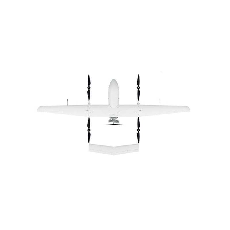
Body length: 2.3 meters
Wingspan: 4.6 meters
Maximum takeoff weight: 45kg
2. mission load and endurance
Maximum mission load: 10kg
Endurance: 350600 minutes (I. e. 5.810 hours), depending on load and flight conditions
Effective control radius: 200km
3. flight performance
Economic cruising speed: 90 km/h
Maximum flight speed: 150 km/h
Wind resistance: 7 (that is, the wind speed between 13.9~17.1 m/s)
Service ceiling: 6500 meters
Maximum take-off altitude: 4000 meters
Take-off and landing mode: vertical take-off and landing
4. Navigation and Positioning
Navigation system: Beidou differential GPS navigation system
Positioning accuracy: high precision, the specific value may vary depending on the configuration and application scenarios
Navigation module: supports Beidou, GNSS, GLONASS and other navigation and positioning systems, providing RTK function
Dual redundant navigation: automatic and smooth switching to auxiliary navigation system in case of failure of main navigation module
5. Engines and Fuels
Engine type: domestic four-stroke EFI engine (optional gasoline version and heavy oil version)
Engine features: independent intellectual property rights, low vibration, low fuel consumption, low noise, long life
6. other parameters and characteristics
Disassembly time: the system can realize 15 minutes of rapid expansion and 10 minutes of rapid withdrawal
Take-off and landing platform: support vehicle, ship mobile platform take-off and landing and off-site different ship take-off and landing.
Configuration mode: it can be configured into different operation modes such as single station single machine, single station multi machine, single machine multi station and so on according to different application scenarios such as air space, air sea and so on.
Expansibility: large cabin space, rich mechanical and electrical interfaces, universal and modular design, with the ability to expand and mount multiple task loads
Safety: integrated heating and drainage type pitot tube, double magnetic compass and other technologies, with waterproof, salt spray performance
Data link range: 200km (same as effective control radius)
In summary, JOUCW-40 UAV has a wide range of applications in military and civilian fields with its excellent performance parameters and diversified functional characteristics. Whether it is to carry out long-distance monitoring tasks, or to carry out reconnaissance and surveying and mapping operations in complex environments, CW-40 have shown strong strength and adaptability..
Logistics information


Logistics information
Technical Specifications
| GNSS Features | Channels | 1408 |
| GPS | L1C/A, L2C, L2P, L5 | |
| GLONASS | L1C/A,L1P,L2C/A,L2P,L3* | |
| BDS | BDS-2: B1I, B2I, B3I BDS-3: B1I, B3I, B1C, B2a, B2b* | |
| GALILEO | E1, E5A, E5B, E6C, AltBOC* | |
| SBAS(WAAS/MSAS/EGNOS/GAGAN) | L1C/A, L5* | |
| IRNSS | L5* | |
| QZSS | L1, L2C, L5* | |
| MSS L-Band | BDS-PPP | |
| Positioning output rate | 1Hz~20Hz | |
| Initialization time | < 10s | |
| Initialization reliability | > 99.99% | |
| Positioning Precision | Code differential GNSS | Horizontal: 0.25 m + 1 ppm RMS Vertical: 0.50 m + 1 ppm RMS |
| Static(long observations) | Horizontal: 2.5 mm + 0.1 ppm RMS Vertical: 3 mm + 0.4 ppm RMS | |
| Static | Horizontal: 2.5 mm + 0.5 ppm RMS Vertical: 3.5 mm + 0.5 ppm RMS | |
| Rapid static | Horizontal: 2.5 mm + 0.5 ppm RMS Vertical: 5 mm + 0.5 ppm RMS | |
| PPK | Horizontal: 3 mm + 1 ppm RMS Vertical: 5 mm + 1 ppm RMS | |
| RTK(UHF) | Horizontal: 8 mm + 1 ppm RMS Vertical: 15 mm + 1 ppm RMS | |
| RTK(NTRIP) | Horizontal: 8 mm + 0.5 ppm RMS Vertical: 15 mm + 0.5 ppm RMS | |
| RTK initialization time | 2-8s | |
| SBAS positioning | Typically < 5m 3DRMS | |
| IMU | Less than 10mm + 0.7 mm/° tilt to 30° | |
| IMU tilt angle | 0° ~ 60° | |
| Hardware Performance | Dimension | 151mmx151mmx94.5mm |
| Weight | 1350g | |
| Material | Magnesium aluminum alloy shell | |
| Operating temperature | -45℃ ~ +65℃ | |
| Storage temperature | -45℃ ~ +85℃ | |
| Humidity | 100% Non-condensing | |
| Waterproof/Dustproof | IP68 standard, protected from long time immersion to depth of 1m | |
| IP68 standard, fully protected against blowing dust | ||
| Shock/Vibration | Withstand 2 meters pole drop onto the cement ground naturally | |
| Power consumption | 2W | |
| Power supply | 6-28V DC, overvoltage protection | |
| Battery | 7.2v 10200mAh | |
| Battery life(Dual-battery) | 15h(Rover Bluetooth mode) | |
| WIFI | Modem | 802.11 b/g standard |
| WIFI hotspot | AP mode, Receiver broadcasts its hotspot form web UI accessing with any mobile terminals | |
| WIFI datalink | Client mode, Receiver can transmit and receive correction data stream via WiFi datalink | |
| Communications | I/O Port | 5-PIN LEMO external power port + RS232 |
| 7-PIN LEMO(USB, OTG and Ethernet) | ||
| 1 PPS data interface | ||
| SIM card slot(standard) | ||
| Internal UHF | Receiver and transmitter 1/2/3W (Just receiver 0.01W for Russia) | |
| Frequency range | 410 - 470MHz | |
| Communication protocol | Farlink, Trimtalk450s, SOUTH, HUACE, ZHD | |
| Communication range | Typically 10km with Farlink protocol | |
| Cellular mobile network | 4G network communication module | |
| Bluetooth | BLEBluetooth 4.0 standard, Bluetooth 2.1 + EDR | |
| NFC Communication | Realizing close range (shorter than 10cm) automatic pair between receiver and controller (controller requires NFC wireless communication module else) | |
| Data Storage/Transmission | Storage | 16GB SSD |
| Automatic cycle storage (The earliest data files will be removed automatically while the memory is not enough) | ||
| Support external USB storage | ||
| Data transmission | Plug and play mode of USB data transmission | |
| Supports FTP/HTTP data download | ||
| Data format | Static data format: STH, Rinex2.01, Rinex3.02, etc. | |
| Differential format: CMR(GPS only), CMR+(GPS only), RTCM 2.3, RTCM 3.0, RTCM 3.1, RTCM 3.2 | ||
| Navigation data format: NMEA 0183, PJK, Binary code | ||
| Network model support: VRS, FKP, MAC, fully support NTRIP protocol | ||
| Sensors | Electronic bubble | Controller software can display electronic bubble, checking leveling status of the carbon pole in real-time |
| IMU | Built-in IMU module, calibration-free and immune to magnetic interference | |
| Thermometer | Built-in thermometer sensor, adopting intelligent temperature control technology, monitoring and adjusting the receiver temperature | |
| User Interaction | Operating system | Linux |
| Buttons | Single button | |
| Indicators | 4 color LED indicators, Battery indicator | |
| Web interaction | With the access of the internal web interface management via WiFi or USB connection, users are able to monitor the receiver status and change the configurations freely | |
| Voice guidance | It provides status and operation voice guidance, and supports Chinese/English/Korean/Spanish/Portuguese/Russian/Turkish | |
| Secondary development | Provides secondary development kit, and opens the OpenSIC observation data format and interaction interface definition | |
| Cloud service | The powerful cloud platform provides online services like remote manage, firmware update, online register and etc. |
Note:
[1]QZSS L6 can be provided by firmware upgrade.
[2]The measurement accuracy, precision, reliability and initialization time depend on various factors, including tilt angle, number of satellites, geometric distribution, observation time, atmospheric conditions and multi-path validation, etc. The data are derived under normal conditions.
[3]Accuracies are dependent on GNSS satellite availability. Hi-Fix Positioning ends after 5 minutes without differential data.Hi-Fix is not available in all regions, check with your local sales representative for more information.
[4]Irregular operations such as rapid rotation and high-intensity vibration may affect the inertial navigation accuracy.
[5]The battery operating time is related to the operating environment, operating temperature and battery life.
Descriptions and Specifications are subject to change without notice