


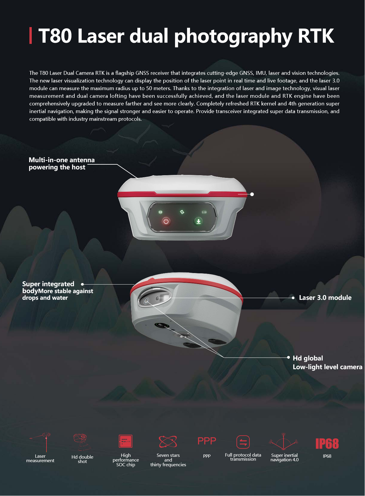
COMNAV T80 Laser Dual-Camera RTKRTK GPS GNSSGPS RTK HIGH PRECISION SURVEY EQUIPMENT GNSS
camera parameters
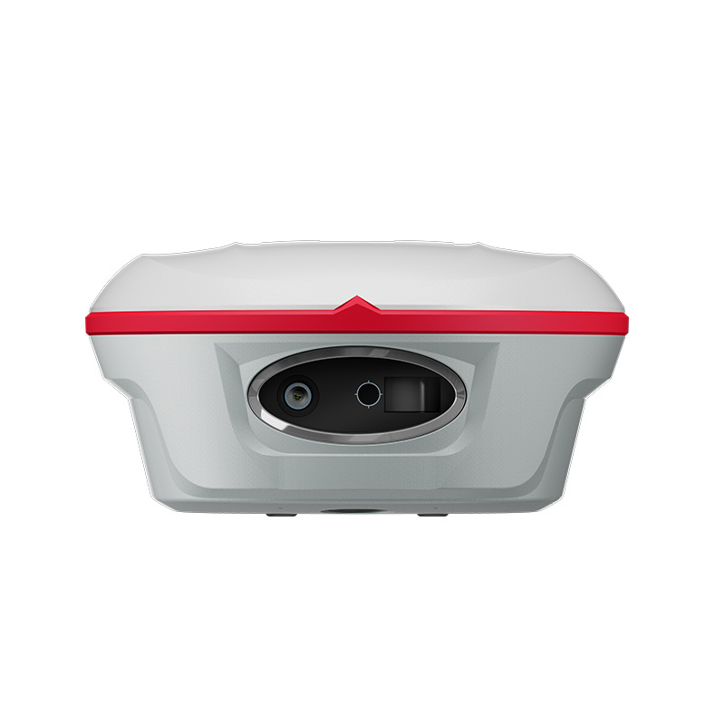
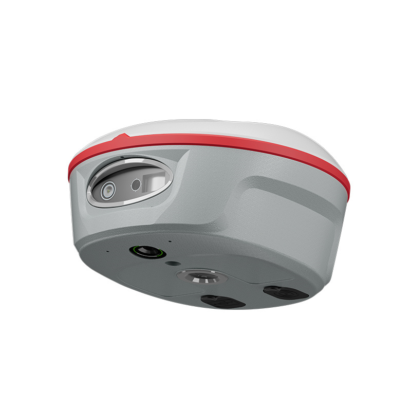
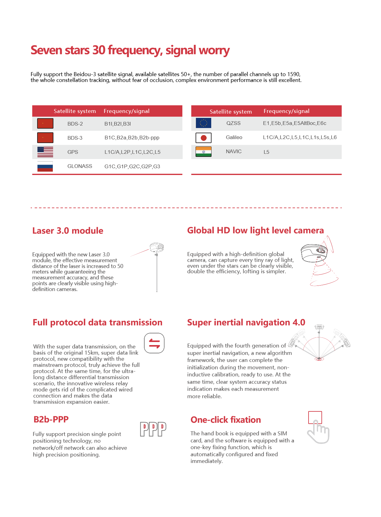
Camera type: HD global low light level camera
Function: support image independent zoom, real-time refresh lofting interface, accuracy is better than 1cm
Application: Support 360-degree AR lofting of handbook and seamless switching of host image lofting
data transfer parameters
Transmission distance: up to 15km
Protocol compatibility: compatible with mainstream industry protocols
Wireless relay mode: support for differential transmission over long distances
Inertial Navigation System Parameters
Inertial navigation system: the fourth generation super inertial navigation system
Initialization mode: no sense of initialization
Calibration mode: Support calibration during exercise
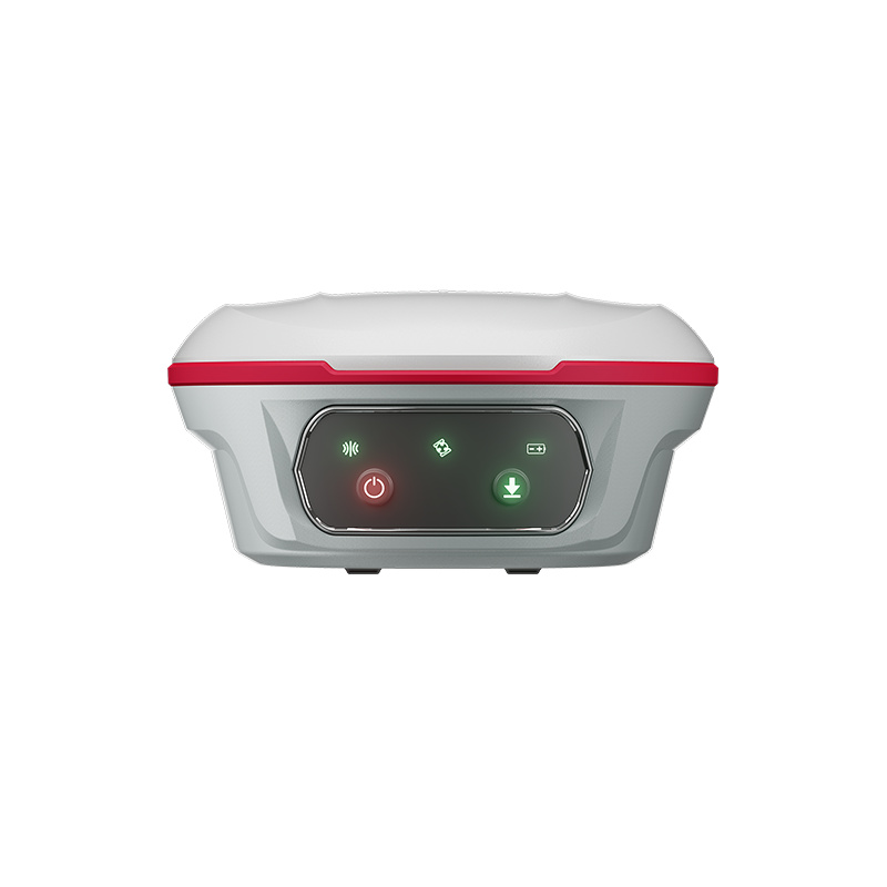
Accuracy Status Indication: Visualization
other parameters
Application scenarios: construction, topographic mapping, natural resource management and other fields
Additional function: video measurement function (only need to take a 5-second video to be measured when the object moves)
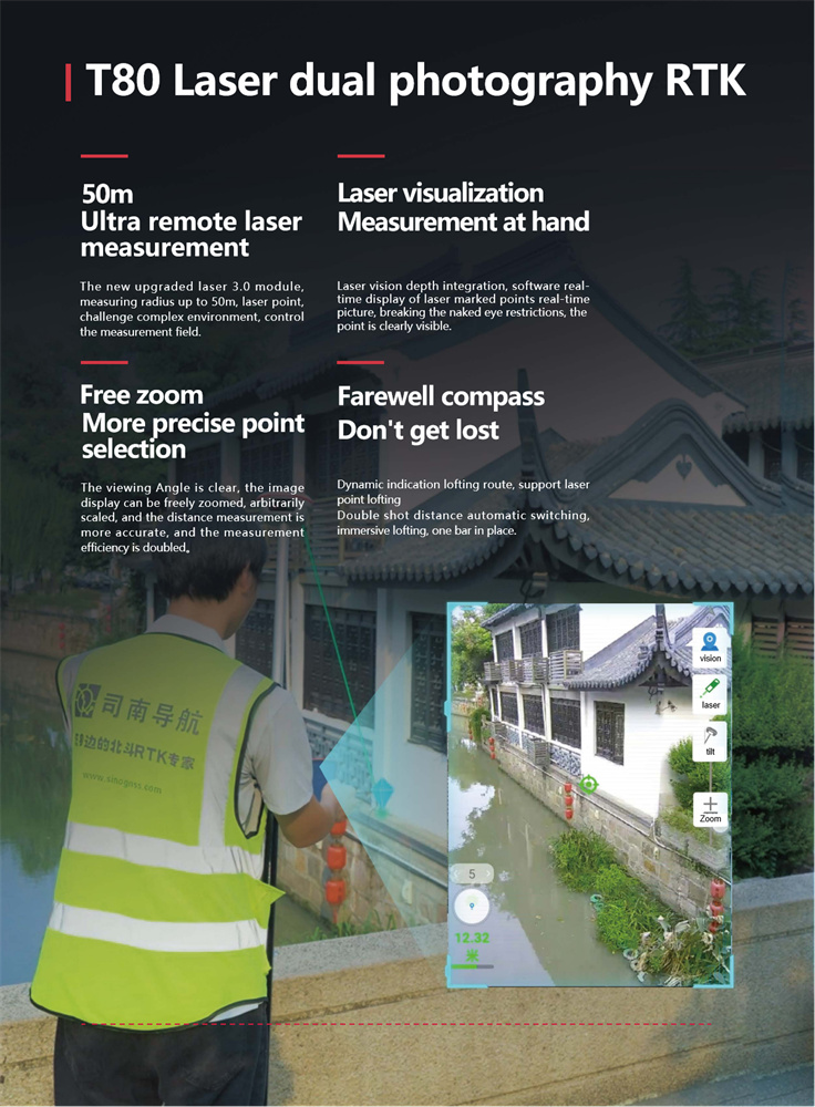
Features: laser eye lofting (applicable to lofting in occlusion scenes)
In summary, the COMNAV T80 RTK integrates a variety of cutting-edge technologies with high accuracy, high reliability and a wide range of application scenarios. Its detailed parameter configuration enables users to meet the needs of high-precision positioning in different fields.
Technology Integration and Laser Measurement
data transmission and compatibility
inertial navigation system and measurement accuracy
T80 RTK is equipped with the fourth generation super inertial guidance system. The new algorithm framework enables users to complete the initial non-sense calibration during exercise, which is ready to use.
Inertial navigation accuracy status visualization, so that users more clearly understand the measurement status, improve the reliability and accuracy of the measurement.
The measurement method of laser intersection is supported. By measuring the same target point in at least four different directions, the object observation model is constructed, the system error is eliminated, and the measurement accuracy is greatly improved.
application scenarios and efficiency improvement
T80 RTK can perform well in all kinds of scenes, especially in occlusion scenes, such as pipeline positioning under viaduct, etc. When traditional RTK cannot perform lofting normally, T80 RTK can be easily completed through a new laser eye lofting method.
The side camera not only enhances the laser function, but also greatly improves the work efficiency by combining the double camera in the visual direction scene. The lofting path is guided by the front camera at a long distance, and the lofting point is automatically switched to the lower camera at a short distance. The detail 1 rod is in place, and the efficiency is improved by 30%.
price and cost performance
Considering that the T80 RTK integrates a variety of cutting-edge technologies and provides high-precision and high-reliability measurement data, its price is relatively reasonable.
For users who need high-precision positioning, long-distance differential transmission and measurement in complex scenarios, T80 RTK has a high cost performance.
In summary, the COMNAV T80 RTK is the 1 flagship GNSS receiver that integrates multiple cutting-edge technologies with high accuracy and reliability. It performs well in laser measurement, data transmission, inertial navigation system and application scenarios, and has high cost performance and practical value.
Logistics information


Technical Specifications
| GNSS Performance | Channels | 1668 |
| GPS | L1C/A, L1C, L2P, L2C, L5 | |
| GLONASS | G1, G2, G3 | |
| Galileo | E1, E5a, E5b, E6c, E5 AItBOC | |
| BeiDou | B1l, B2l, B3l, B1C, B2a, B2b | |
| QZSS | L1C/A, L2C, L5, L1C | |
| PPP | B2b-PPP | |
| SBAS (EGNOS Support) | L1, L5 | |
| GNSS Accuracies | Real time kinematic (RTK) | H: 8 mm + 1 ppm RMS |
| V: 15 mm + 1 ppm RMS | ||
| Initialization time: <10 s | ||
| Initialization reliability: >99.9% | ||
| Post-processing kinematic (PPK) |
H: 3 mm + 1 ppm RMS V: 5 mm + 1 ppm RMS |
|
| High-precision static | H: 2.5 mm + 0.1 ppm RMS V: 3.5 mm + 0.4 ppm RMS |
|
| Static and rapid static | H: 2.5 mm + 0.5 ppm RMS V: 5 mm + 0.5 ppm RMS |
|
| Code differential | H: 0.4 m RMS | V: 0.8 m RMS | |
| Autonomous | H:1.5 m RMS | V: 2.5 m RMS | |
| Visual survey | Typical 2~4 cm, range 2~15 m | |
| Positioning rate | 1 Hz, 5 Hz and 10 Hz | |
| Time to first fix | Cold start: < 45 s, Hot start: < 10 s Signal re-acquisition: < 1 s |
|
| IMU update rate | 200 Hz | |
| Till angle | 0-60° | |
| RTK tilt-compensated | Additional horizontal pole-tilt uncertainty typically less than 8 mm + 0.7 mm/° tilt |
|
| Environments | Temperature | Operating: -40°C to +65°C |
| (-40°F to +149°F) | ||
| Storage: -40°C to +85°C | ||
| (-40°F to +185°F) | ||
| Humidity | 100% non-condensation | |
| Ingress protection | IP68(6) (according to IEC 60529) | |
| Drop | Survive a 2-meter pole-drop | |
| Vibration | Compliant with ISO 9022-36-08 and MIL-STD-810G- 514.6-Cat.24. |
|
| Waterproof and breathable membrane |
Prevent water vapor from entering under harsh environments |
|
| Electrical | Power consumption | UHF/ 4G RTK Rover w/o camera: |
| Typical 2.8 W | ||
| Visual Stakeout/Visual Survey: | ||
| Typical 4 W | ||
| Li-ion battery capacity | Built-in non-removable battery 9,600 mAh, 7.4 V |
|
| Operating time on internal battery |
UHF/ 4G RTK Rover w/o camera: | |
| up to 34 h | ||
| Visual Stakeout/Visual Survey: | ||
| up to 24 h | ||
| UHF RTK Base: up | ||
| External power input | 9 V DC to 24 V DC | |
| Hardware | Size (D x H) | Φ 15.5cm x 7.3cm |
| Weigh | 1.2kg with two batteries | |
| Front pane | 1.1'' OLED Color Display | |
| 2 LED, 2 physical buttons | ||
| Tilt sensor | Calibration-free IMU for pole-tilt compensation. Immune to magnetic disturbances. E-Bubble leveling. |
|
| Cameras | Sensor pixels | Global shutter with 2 MP & 5 MP |
| Field of view | 75° | |
| Video frame rate | 25 fps | |
| Image group capture | Method: video photogrammetry. Rate: typically 2 Hz, up to 25Hz. Max. capture time: 60s with an image group size of appr. 60MB |
|
| Illumination | Starlight-grade camera. OmniPixel® -GS technology. Maintain full color at illumination levels as low as 0.01 lux |
|
| Communication | SIM card type | Nano-SIM card |
| Network modem | Integrated 4G modem: TDD-LTE, FDD-LTE, WCDMA, EDGE, GPRS, GSM |
|
| Wireless connection | NFC for device touch pairing | |
| Wi-F | Wi-Fi IEEE 802.11a/b/g/n/ac, access point mode |
|
| Bluetooth | 5.0 and 4.2 +EDR, backward compatible |
|
| Ports | 1 x 7-pin LEMO port (RS-232) 1 x USB Type-C port (external power, data download, firmware update) 1 x UHF antenna port (TNC female) |
|
| Built-in UHF radio | Rx/Tx: 410 - 470 MHz Transmit Power: 0.5 W to 2 W Protocol: CHC, Transparent, TT450, Satel Link rate: 9 600 bps to 19 200 bps Range: Typical 3 km to 5 km, up to 15 km with optimal conditions |
|
| Data formats | RTCM 2.x, RTCM 3.x, CMR input / output HCN, HRC, RINEX 2.11, 3.02 NMEA 0183 output NTRIP Client, NTRIP Caster |
|
| Data storage | 32 GB internal memory. Support 128 GB external expansion |