


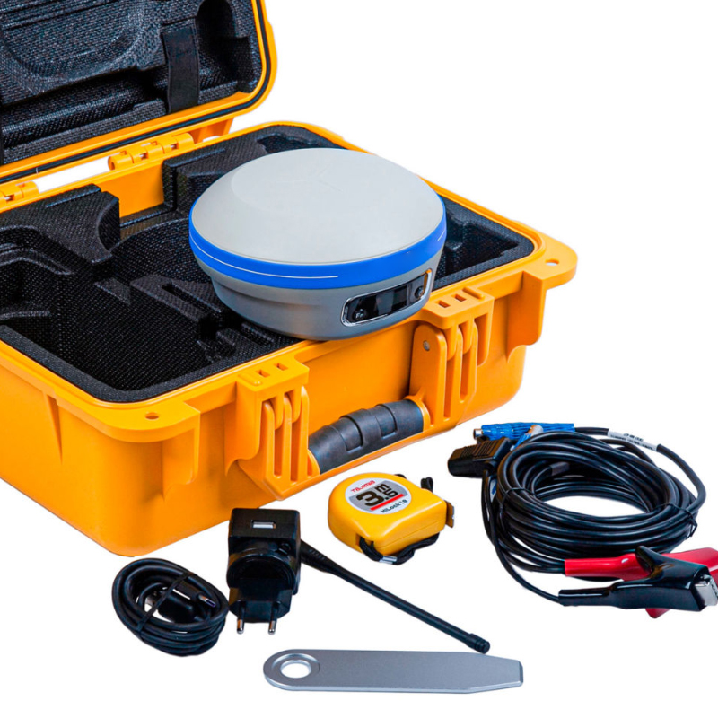
CHCNAV X7/I83 GNSS Receiver with UM980 Motherboard and IMU for Land Surveying Base Kit And Rover Kit Price
Technical Features
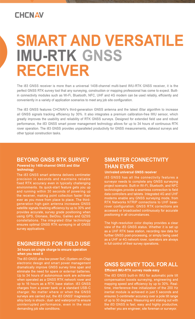
ENGINEERED FOR FIELD USE
34 hours on single charge to ensure operation when you need it
The i83 GNSS ultra-low-power SoC (System-on-Chip) electronic design and smart power management dramatically improve GNSS survey time span and eliminate the need for spare or external batteries. Up to 34 hours of autonomous work are achieved when operated as a GNSS RTK network rover and up to 16 hours as an RTK base station. i83 GNSS charges from a power bank or a standard USB-C charger. No matter where or when the GNSS surveys are carried out, the i83 GNSS' magnesium alloy body is shock-, dust- and waterproof to ensure uninterrupted performance, even in the most demanding job site conditions.
SMARTER CONNECTIVITY THAN EVER
Unrivaled universal GNSS receiver
i83 GNSS has all the connectivity features a surveyor needs to complete any GNSS surveying project scenario. Built-in Wi-Fi, Bluetooth, and NFC technologies provide a seamless connection to field data controllers and tablets. Integrated 4G and UHF modems enable any GNSS surveying mode, from RTK Networks NTRIP connections to UHF base- rover configuration. GNSS RTK corrections are accessed or broadcasted continuously for accurate positioning in all circumstances. The high-resolution color display provides a clear view of the i83 GNSS status. Whether it is set up as a UHF RTK base station, recording raw data for further GNSS post-processing, or simply being used as a UHF or 4G network rover, it provides the full control of survey operations.
GNSS SURVEY TOOL FOR EVERYONE
Efficient IMU-RTK survey made easy
The i83 GNSS built-in IMU for automatic pole tilt compensation boosts surveying, engineering, and mapping speed and efficiency by up to 30%. Real-time, interference-free initialization of the 200 Hz inertial module is achieved in just 5 seconds and ensures 3-centimeter accuracy over a pole tilt range of up to 30 degrees. Measuring and staking out with the i83 GNSS is fast, easy, and highly productive, whether you are an engineer, site foreman, or surveyor
advantage
Compared to other GNSS (Global Navigation Satellite System) receivers, the CHCNAV X7/I83 RTK offers numerous advantages, as detailed below:
I. High Precision and Efficiency
High-precision Positioning: The CHCNAV X7/I83 RTK employs advanced satellite antennas and differential positioning technology to achieve centimeter- or even millimeter-level positioning accuracy, which is crucial for surveying engineering.
Efficient Operational Capability: The CHCNAV X7/I83 RTK is equipped with a high-capacity lithium battery and Huace's power management solution, enabling the rover to operate continuously for up to 18 hours in typical environments, significantly enhancing work efficiency. Additionally, its AI-powered automatic road data compilation service reduces manual operation and further improves efficiency.
II. Intelligence and Ease of Use
AI Technology Integration: The CHCNAV X7/I83 RTK integrates Huace's latest AI technology, which automatically compiles road files based on user-uploaded road drawings, accelerating the entire road construction process.
User-friendly Interface: The CHCNAV X7/I83 RTK features a simple and intuitive operation interface, allowing users to operate it without extensive training. Furthermore, it supports multiple connection methods, such as NFC and Landstar Bluetooth, making it easier to connect to instruments and set up CORS modes.
III. Compatibility and Adaptability
Comprehensive Compatibility with Five Satellites and Sixteen Frequencies: The CHCNAV X7/I83 RTK is fully compatible with signals from GPS, GLONASS, Galileo, BDS, and other global navigation satellite systems, enhancing the receiver's compatibility and reliability.
Adaptability to Various Measurement Scenarios: The CHCNAV X7/I83 RTK is not only suitable for infrastructure construction projects such as road construction but also widely applicable to land surveying, topographic mapping, mineral resource exploration, and other fields, demonstrating its strong adaptability and flexibility.
IV. Signal Stability and Battery Life
Signal Stability: The CHCNAV X7/I83 RTK adopts a third-generation high-gain satellite antenna, improving satellite acquisition and locking efficiency by 30% and signal-to-noise ratio by 5%, ensuring more reliable signals in harsh environments.
Long Battery Life: With its built-in high-capacity lithium battery and power management solution, the rover can operate continuously for up to 18 hours in typical environments, meeting the challenges of various complex project durations.
In summary, the CHCNAV X7/I83 RTK demonstrates significant advantages over other GNSS receivers in terms of precision, efficiency, intelligence, ease of use, compatibility, adaptability, signal stability, and battery life. These advantages make the CHCNAV X7/I83 RTK a highly promising and competitive product in the field of surveying engineering.
parameters
The parameters of the CHCNAV X7/I83 can be detailed in the following aspects:
I. Satellite and Accuracy
Supported satellite systems include: BDS (B1I, B2I, B3I, B1C, B2a, B2b), GPS (L1C/A, L2P, L2C, L5C, L1C), GLONASS (G1, G2), Galileo (E1, E5a, E5b), and QZSS (L1, L2, L5).
Supports Precise Point Positioning (PPP) with an initialization reliability greater than 99.99%.
Static accuracy: Planar accuracy is ±2.5mm + 0.5×operating distance×10-6mm.
RTK accuracy: Planar accuracy is ±8mm + 0.5×operating distance×10-6mm.
II. GNSS + Inertial Navigation
IMU update rate is 200Hz.
Tilt angle ranges from 0° to 60°.
Tilt compensation accuracy is 10mm + 0.7mm/°tilt (accuracy within 30° is less than 2.5cm).
III. User Interaction
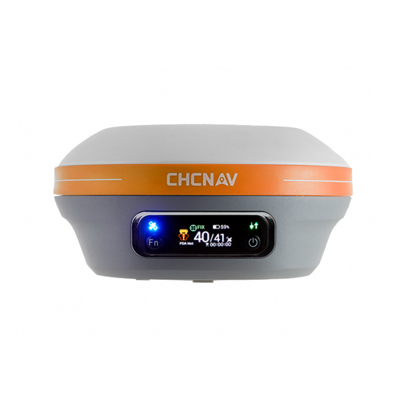
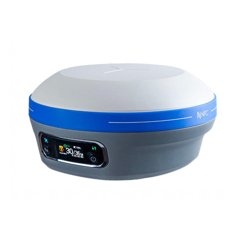
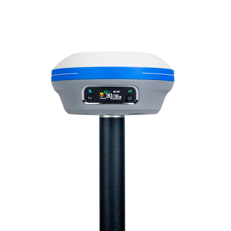
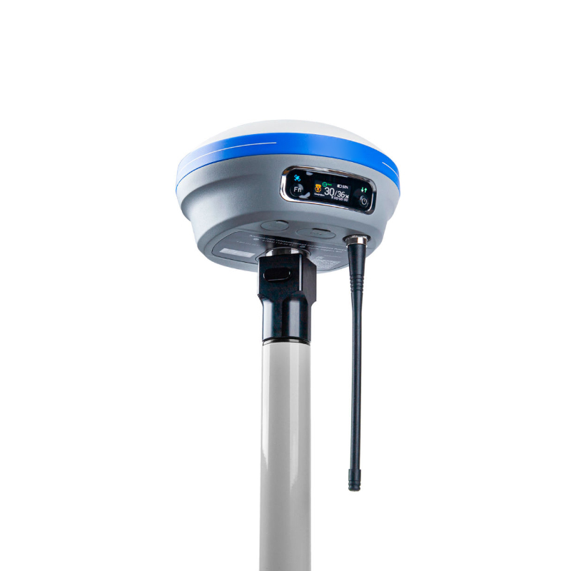
Equipped with a quasi-retina screen LCD for clear display even under direct sunlight.
Features one satellite indicator light, one differential data indicator light, as well as function keys such as Fn, power/confirm, etc.
Supports PC/mobile web access and has a voice broadcast function.
IV. Physical Characteristics
Dimensions are Φ152mm×78mm, made of magnesium alloy, and the weight is 1.25kg.
Operating temperature range is from -45℃ to +75℃, and storage temperature range is from -55℃ to +85℃.
Designed with a waterproof and breathable membrane to prevent moisture ingress in harsh environments.
Waterproof and dustproof rating is IP68 (can withstand 30 minutes of submersion in 1 meter of water), and the impact resistance rating is IK08 (can withstand the mechanical impact of a 2.5kg steel hammer without damage and is resistant to 3-meter drops).
V. Electrical Performance
Built-in dual batteries with a typical battery life of 18 hours for mobile stations, and supports up to 15w fast charging.
External power supply range is (9~28)V DC.
Storage capacity is 32GB, and supports the electronic bubble function.
VI. Wireless Communication
Supports high-speed network communication modules for all major carriers, WIFI, Bluetooth, and NFC data links.
Built-in transceiver with a maximum transmit power of 2w, supporting CHCNAV/TT450/transparent transmission protocols.
VII. Control Handbook
Model is the HCE600 Android surveying handbook.
Operating system is Android 10.
CPU is an octa-core 2.0GHz processor.
Supports 4G network for all major carriers, with an embedded eSIM and a complimentary three-year surveying data plan.
Features a 5.5-inch high-definition LCD screen, with a battery life of 14 hours, and a waterproof and dustproof rating of IP68.
VIII. Other Functions
Supports SBAS regional augmentation services, with an SBAS differential positioning accuracy of less than 1.0m.
Data formats supported include CHCNAV's custom HCN/HRC formats (ultra-high compression ratio) as well as international standard formats such as RTCM2.X, RTCM3, and X.
Logistics information


Logistics information
technical parameter
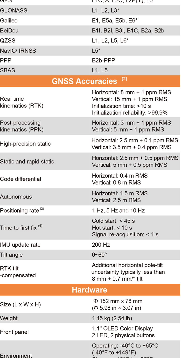
| GNSS Performance | Channels | 1408 channels |
| GPS | L1C, A, L2C, L2P(Y), L5 | |
| GLONASS | L1, L2, L3 | |
| Galileo | E1, E5a, E5b, E6* | |
| BeiDou | B1I, B2I, B3I, B1C, B2a, B2b | |
| QZSS | L1, L2, L5, L6* | |
| PPP | B2b-PPP | |
| SBAS (EGNOS Support) | L1, L5 | |
| GNSS Accuracies | Real time kinematic (RTK) | H: 8 mm + 1 ppm RMS |
| V: 15 mm + 1 ppm RMS | ||
| Initialization time: <10 s | ||
| Initialization reliability: >99.9% | ||
| Post-processing kinematic (PPK) | H: 3 mm + 1 ppm RMS V: 5 mm + 1 ppm RMS | |
| High-precision static | H: 2.5 mm + 0.1 ppm RMS V: 3.5 mm + 0.4 ppm RMS | |
| Static and rapid static | H: 2.5 mm + 0.5 ppm RMS V: 5 mm + 0.5 ppm RMS | |
| Code differential | H: 0.4 m RMS | V: 0.8 m RMS | |
| Autonomous | H:1.5 m RMS | V: 2.5 m RMS | |
| Visual survey | Typical 2~4 cm, range 2~15 m | |
| Positioning rate | 1 Hz, 5 Hz and 10 Hz | |
| Time to first fix | Cold start: < 45 s, Hot start: < 10 s Signal re-acquisition: < 1 s | |
| IMU update rate | 200 Hz | |
| Till angle | 0-60° | |
| RTK tilt-compensated | Additional horizontal pole-tilt uncertainty typically less than 8 mm + 0.7 mm/° tilt | |
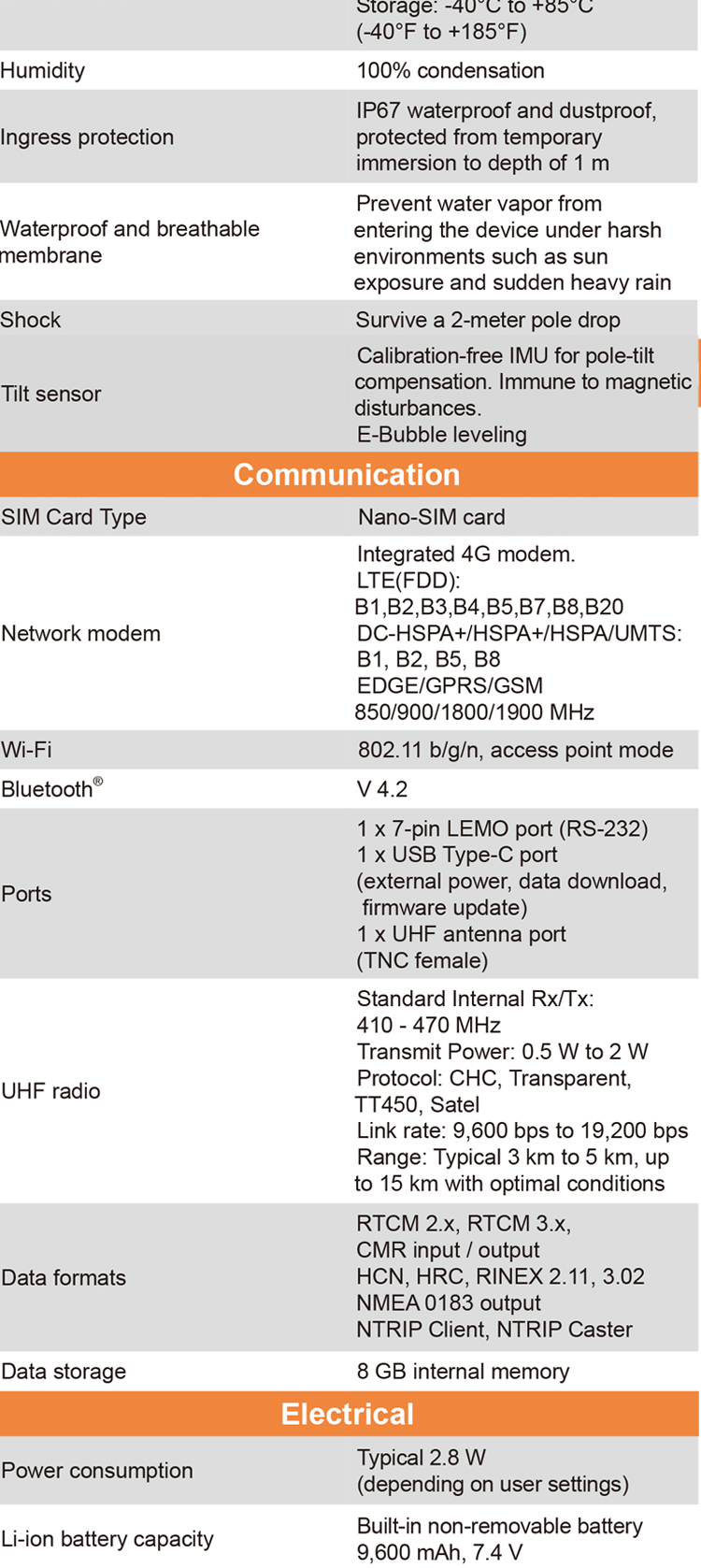
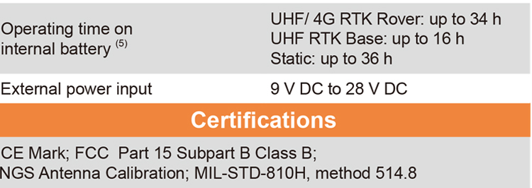
| Environments | Temperature | Operating: -40°C to +65°C |
| (-40°F to +149°F) | ||
| Storage: -40°C to +85°C | ||
| (-40°F to +185°F) | ||
| Humidity | 100% non-condensation | |
| Ingress protection | IP68(6) (according to IEC 60529) | |
| Drop | Survive a 2-meter pole-drop | |
| Vibration | Compliant with ISO 9022-36-08 and MIL-STD-810G- 514.6-Cat.24. | |
| Waterproof and breathable membrane | Prevent water vapor from entering under harsh environments | |
| Electrical | Power consumption | UHF/ 4G RTK Rover w/o camera: |
| Typical 2.8 W | ||
| Visual Stakeout/Visual Survey: | ||
| Typical 4 W | ||
| Li-ion battery capacity | Built-in non-removable battery 9,600 mAh, 7.4 V | |
| Operating time on internal battery | UHF/ 4G RTK Rover w/o camera: | |
| up to 34 h | ||
| Visual Stakeout/Visual Survey: | ||
| up to 24 h | ||
| UHF RTK Base: up | ||
| External power input | 9 V DC to 24 V DC | |
| Hardware | Size (D x H) | 152 mm x 78 mm (Φ 5.98 in × 3.07 in) |
| Weigh | 1.15 kg (2.54 lb) | |
| Front pane | 1.1'' OLED Color Display | |
| 1.1'' OLED Color Display 2 LED, 2 physical buttons | ||
| Tilt sensor | Calibration-free IMU for pole-tilt compensation. Immune to magnetic disturbances. E-Bubble leveling. | |
| Communication | SIM card type | Nano-SIM card |
| Network modem | Integrated 4G modem: TDD-LTE, FDD-LTE, WCDMA, EDGE, GPRS, GSM | |
| Wireless connection | NFC for device touch pairing | |
| Wi-F | Wi-Fi IEEE 802.11a/b/g/n/ac, access point mode | |
| Bluetooth | 5.0 and 4.2 +EDR, backward compatible | |
| Ports | 1 x 7-pin LEMO port (RS-232) 1 x USB Type-C port (external power, data download, firmware update) 1 x UHF antenna port (TNC female) | |
| Built-in UHF radio | Rx/Tx: 410 - 470 MHz Transmit Power: 0.5 W to 2 W Protocol: CHC, Transparent, TT450, Satel Link rate: 9 600 bps to 19 200 bps Range: Typical 3 km to 5 km, up to 15 km with optimal conditions | |
| Data formats | RTCM 2.x, RTCM 3.x, CMR input / output HCN, HRC, RINEX 2.11, 3.02 NMEA 0183 output NTRIP Client, NTRIP Caster | |
| Data storage | 32 GB internal memory. Support 128 GB external expansion |