


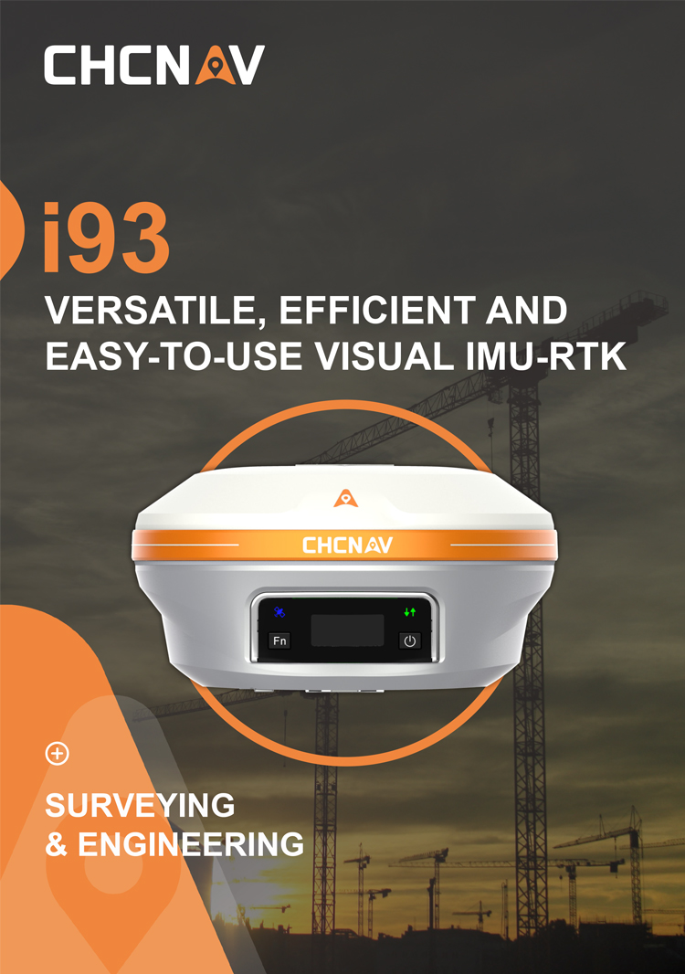
CHCNAV i93+(X16) IMU Ibase RTK GPS Gnssgps RTK High Precision Survey Equipment Gnss
Technical Features
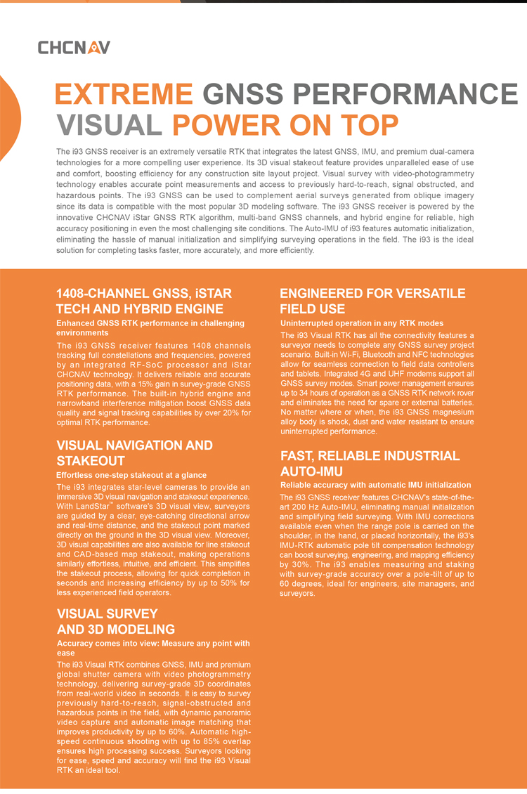
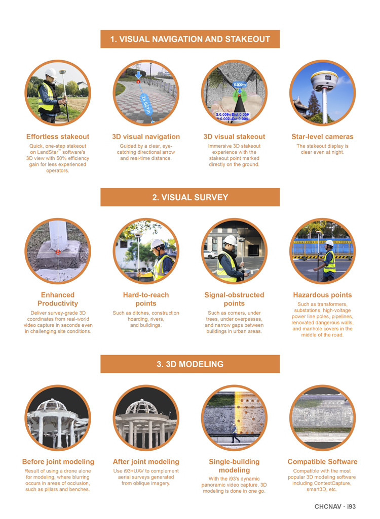
Easy measurements: See accuracy in 3D
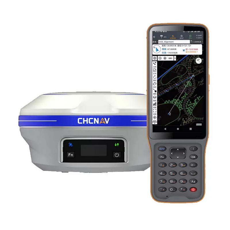
The i93 is a cutting-edge surveying tool that combines GNSS, IMU, and two premium global shutter cameras with video photogrammetry technology. It delivers survey-grade 3D coordinates from real-world video capture in seconds, making it easy to survey previously hard-to-reach, signal-obstructed, and hazardous points in the field, such as under overpasses, under eaves, and near power poles. With its dynamic panoramic video capture and automatic image matching, the i93 improves productivity by up to 60%. Automatic high-speed continuous shooting and adjacent image generation with up to 85% overlap ensure high processing success. Surveyors looking for ease, speed, and accuracy will find the i93 an ideal tool.
Reliable accuracy with automatic IMU initialization
The i93 GNSS features CHCNAV's state-of-the-art 200Hz Auto-IMU, which eliminates the need for manual initialization and simplifies surveying operations in the field. With IMU corrections available even when the range pole is carried on the shoulder, in hand, or placed horizontally, the i93's IMU-RTK automatic pole tilt compensation technology can boost surveying, engineering, and mapping speed and efficiency by up to 30%. Measuring and staking out with survey-grade accuracy over a pole tilt of up to 60 degrees is fast, easy, and highly productive, making the i93 the perfect solution for engineers, site managers, and surveyors.
Uninterrupted operation in any RTK modes
The i93 has all the connectivity features a surveyor needs to complete any GNSS survey project scenario. Built-in Wi-Fi, Bluetooth, and NFC technologies allow seamless connection to field data controllers and tablets. Integrated 4G and UHF modems support all GNSS survey modes. Smart power management ensures up to 34 hours of operation as a GNSS RTK network rover and eliminates the need for spare or external batteries. No matter where or when, the i93 GNSS magnesium alloy body is shock, dust, and water resistant to ensure uninterrupted performance.
advantages
The chcnav i93 GNSS is an integrated high-precision positioning and advanced technology measurement device, and its advantages are mainly reflected in the following aspects:
I. High-precision Positioning and Powerful Signal Reception Capability
Integrated Baseband-RF SoC Chip: The chcnav i93 GNSS employs an advanced integrated baseband-RF SoC chip, supporting 21 frequency points across five satellite systems, and is equipped with multi-frequency anti-interference technology. Its typical signal acquisition sensitivity reaches -162dBm, demonstrating strong signal reception capabilities.
Satellite-based Differential Technology: Even without a communication network, the chcnav i93 GNSS can maintain high-precision positioning, thanks to its satellite-based differential technology.
II. Efficient Operational Performance
Visual RTK Operation: The chcnav i93 GNSS supports visual RTK operation, and its "one-rod placement" function significantly improves operational efficiency. According to actual test data, compared to traditional methods, using the chcnav i93 GNSS can increase efficiency by 50%.
Dual-Engine Calculation Technology: This technology can check and correct flying points, ensuring the accuracy of measurement data and further enhancing operational efficiency.
III. Rich Advanced Features
Surveying and Mapping Software 8.0: The chcnav i93 GNSS is equipped with Surveying and Mapping Software 8.0, which improves graphic operation fluency by 52%. Through the self-developed "MetaCAD" 2D and 3D integrated graphic engine, it achieves millisecond-level dynamic response. Additionally, the software supports seamless compatibility with 99.9% of CAD drawings, greatly facilitating the work of engineering surveyors.
Cloud Services and AI Automatic Editing: The chcnav i93 GNSS provides cloud services, AI automatic editing of road files, and other intelligent services, further enhancing user experience and work efficiency.
Video Measurement and 3D Modeling: Integrating GNSS+IMU+dual cameras and fusing video photogrammetry technology, the chcnav i93 GNSS supports video measurement and 3D modeling, enabling efficient batch acquisition of high-precision 3D coordinates from real-world videos and achieving "what you see is what you measure".
AR Real-Scene Navigation and Visual Stakeout: It supports AR real-scene navigation and immersive real-scene 3D stakeout, ensuring accurate placement without getting lost and achieving one-rod placement, further improving operational efficiency.
IV. Excellent Durability and Reliability
Material and Protection Level: The chcnav i93 GNSS is crafted from magnesium alloy and features an IP68 waterproof and dustproof rating, ensuring normal operation in harsh environments.
Impact Resistance: The device is impact-resistant, capable of withstanding certain mechanical impacts without damage, ensuring durability and reliability during actual use.
V. Upgraded Algorithms and Fixed Effects
Huace OneNet™ and Cloud-based Homologous Algorithm: The chcnav i93 GNSS has been upgraded with Huace OneNet™ and Cloud-based Homologous Algorithm 3.0 (or 2.0), allowing real-time ionospheric model matching and mutual correction between the cloud and RTK terminal through exclusive messages. This improves the fixing rate from 85% to 96%, effectively enhancing fixing performance during periods of ionospheric activity.
Logistics information


Logistics information
technical parameter
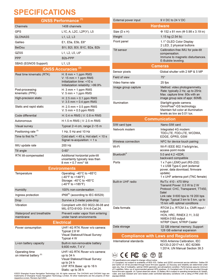
| GNSS Performance | Channels | 1408 channels |
| GPS | L1C, A, L2C, L2P(Y), L5 | |
| GLONASS | L1, L2, L3 | |
| Galileo | E1, E5a, E5b, E6* | |
| BeiDou | B1I, B2I, B3I, B1C, B2a, B2b | |
| QZSS | L1, L2, L5, L6* | |
| PPP | B2b-PPP | |
| SBAS (EGNOS Support) | L1, L5 | |
| GNSS Accuracies | Real time kinematic (RTK) | H: 8 mm + 1 ppm RMS |
| V: 15 mm + 1 ppm RMS | ||
| Initialization time: <10 s | ||
| Initialization reliability: >99.9% | ||
| Post-processing kinematic (PPK) | H: 3 mm + 1 ppm RMS V: 5 mm + 1 ppm RMS | |
| High-precision static | H: 2.5 mm + 0.1 ppm RMS V: 3.5 mm + 0.4 ppm RMS | |
| Static and rapid static | H: 2.5 mm + 0.5 ppm RMS V: 5 mm + 0.5 ppm RMS | |
| Code differential | H: 0.4 m RMS | V: 0.8 m RMS | |
| Autonomous | H:1.5 m RMS | V: 2.5 m RMS | |
| Visual survey | Typical 2~4 cm, range 2~15 m | |
| Positioning rate | 1 Hz, 5 Hz and 10 Hz | |
| Time to first fix | Cold start: < 45 s, Hot start: < 10 s Signal re-acquisition: < 1 s | |
| IMU update rate | 200 Hz | |
| Till angle | 0-60° | |
| RTK tilt-compensated | Additional horizontal pole-tilt uncertainty typically less than 8 mm + 0.7 mm/° tilt | |
| Environments | Temperature | Operating: -40°C to +65°C |
| (-40°F to +149°F) | ||
| Storage: -40°C to +85°C | ||
| (-40°F to +185°F) | ||
| Humidity | 100% non-condensation | |
| Ingress protection | IP68(6) (according to IEC 60529) | |
| Drop | Survive a 2-meter pole-drop | |
| Vibration | Compliant with ISO 9022-36-08 and MIL-STD-810G- 514.6-Cat.24. | |
| Waterproof and breathable membrane | Prevent water vapor from entering under harsh environments | |
| Electrical | Power consumption | UHF/ 4G RTK Rover w/o camera: |
| Typical 2.8 W | ||
| Visual Stakeout/Visual Survey: | ||
| Typical 4 W | ||
| Li-ion battery capacity | Built-in non-removable battery 9,600 mAh, 7.4 V | |
| Operating time on internal battery | UHF/ 4G RTK Rover w/o camera: | |
| up to 34 h | ||
| Visual Stakeout/Visual Survey: | ||
| up to 24 h | ||
| UHF RTK Base: up | ||
| External power input | 9 V DC to 24 V DC | |
| Hardware | Size (D x H) | Φ 152 x 81 mm (Φ 5.98 x 3.19 in) |
| Weigh | 1.15 kg (2.54 lb) | |
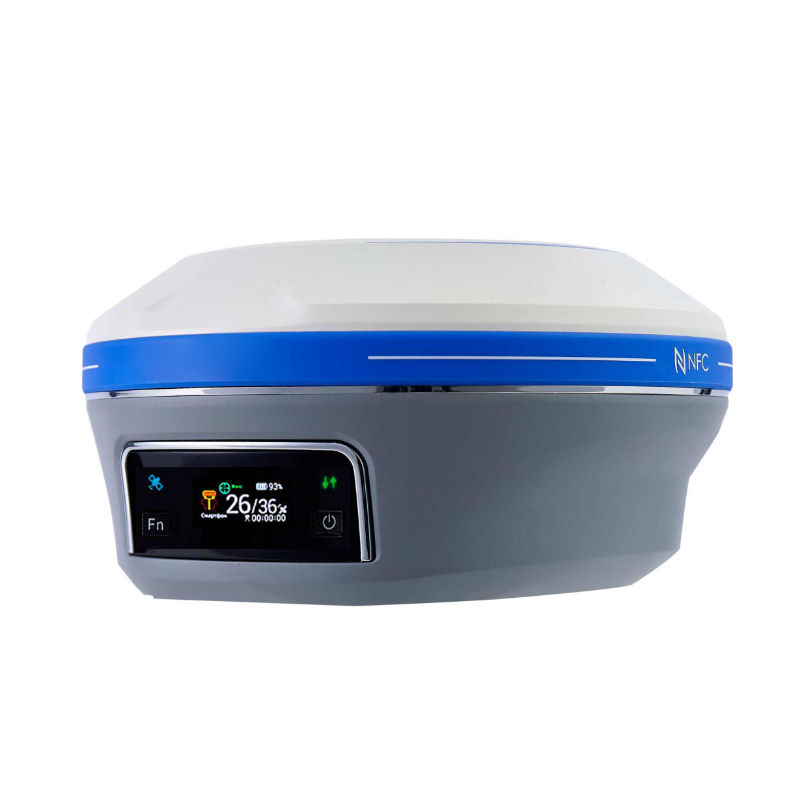
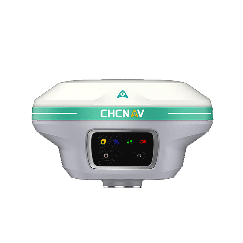
| Front pane | 1.1'' OLED Color Display | |
| 2 LED, 2 physical buttons | ||
| Tilt sensor | Calibration-free IMU for pole-tilt compensation. Immune to magnetic disturbances. E-Bubble leveling. | |
| Cameras | Sensor pixels | Global shutter with 2 MP & 5 MP |
| Field of view | 75° | |
| Video frame rate | 25 fps | |
| Image group capture | Method: video photogrammetry. Rate: typically 2 Hz, up to 25Hz. Max. capture time: 60s with an image group size of appr. 60MB | |
| Illumination | Starlight-grade camera. OmniPixel® -GS technology. Maintain full color at illumination levels as low as 0.01 lux | |
| Communication | SIM card type | Nano-SIM card |
| Network modem | Integrated 4G modem: TDD-LTE, FDD-LTE, WCDMA, EDGE, GPRS, GSM | |
| Wireless connection | NFC for device touch pairing | |
| Wi-F | Wi-Fi IEEE 802.11a/b/g/n/ac, access point mode | |
| Bluetooth | 5.0 and 4.2 +EDR, backward compatible | |
| Ports | 1 x 7-pin LEMO port (RS-232) 1 x USB Type-C port (external power, data download, firmware update) 1 x UHF antenna port (TNC female) | |
| Built-in UHF radio | Rx/Tx: 410 - 470 MHz Transmit Power: 0.5 W to 2 W Protocol: CHC, Transparent, TT450, Satel Link rate: 9 600 bps to 19 200 bps Range: Typical 3 km to 5 km, up to 15 km with optimal conditions | |
| Data formats | RTCM 2.x, RTCM 3.x, CMR input / output HCN, HRC, RINEX 2.11, 3.02 NMEA 0183 output NTRIP Client, NTRIP Caster | |
| Data storage | 32 GB internal memory. Support 128 GB external expansion |