


CHCNAV I76 PALM-SIZED VISUAL IMU-RTK GNSS GPS RTK with 1408 Channels Dual Cameras CAD+AR Visual Stakeout For Land Surveying
Technical Features
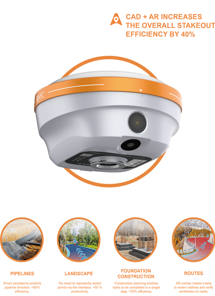
ULTRA-IMU TECHNOLOGY
Boost Accuracy by 30%
The i76 integrates a 5th Gen interference-free Ultra IMU operating at 200 Hz, enhanced by EKF algorithms for optimal measurement accuracy. It includes automatic pole tilt compensation, maintaining accuracy within 3 centimeters even at a 60-degree tilt, and ensuring reliable and user-friendly tilt measurements. The device simplifies operations with its "poke-and-measure" feature, eliminating manual IMU initialization or bubble centering. The IMU functions regardless of the range pole's position, whether handheld, shoulder-mounted, or placed horizontally.
AIR-MEDIUM ANTENNA & HYBRID GNSS ENGINE
Achieve an RTK fix rate of over 96% in solar active regions
The i76 GNSS excels in solar-active and other challenging environments with its 4th Gen air-medium GNSS antenna and hybrid GNSS engine, offering robust tracking of all GNSS constellations and resistance to interference. Enhanced by iStar 2.0 technology, it achieves an RTK fix rate of over 96%, which is ideal for areas with high ionospheric activity. Pairing with CHCNAV base stations, it extends UHF coverage up to 25 km in standard conditions and 5-8 km in areas with obstructed signals, ensuring high-quality data in diverse surveying scenarios.
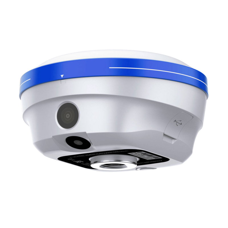
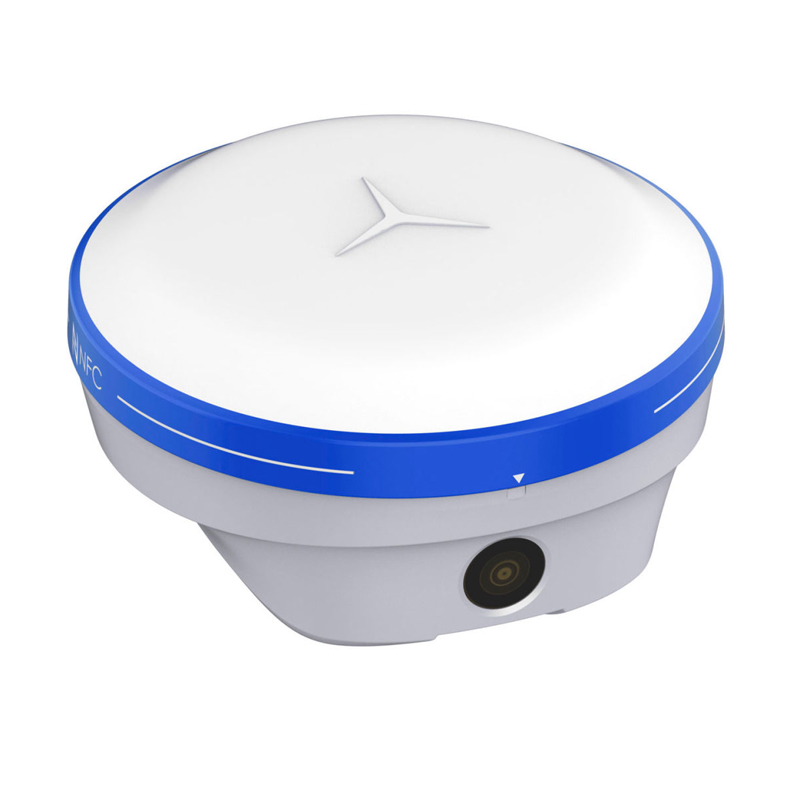
PALM-SIZED WITH GNSS, IMU AND DUAL CAMERAS
Optimize performance with extended endurance and reliable lightweight excellence
The i76 combines lightweight design with rugged durability, weighing just 450g and offering advanced integration of GNSS, Auto-IMU, and dual cameras for seamless surveying. With IP68 protection and 2-meter drop resistance, its durable biomimetic structure and sapphire camera lenses withstand harsh conditions and resist impacts and scratches. Intelligent cloud-based OTA upgrades and an energy-efficient lithium battery provide over 17 hours of continuous operation, ensuring reliability and extended endurance in the field
Performance
CHCNAV i76 Real-Time Kinematic (RTK) is a high-performance, high-precision measurement instrument that excels both in performance and practical application. The following is a detailed analysis of its performance and practicality:
1.High-Precision Positioning:
1.The CHCNAV i76 RTK supports multiple satellite systems, including GPS, BDS (BeiDou), Glonass, Galileo, and QZSS, ensuring stable and high-precision positioning signals globally.
2.In high-precision static measurements, the planar accuracy can reach ±(2.5 + 0.1×10^-6×D) mm, meeting various high-precision measurement requirements.
2.Rapid Initialization and Reliability:
1.The initialization reliability is as high as 99.99%, ensuring the device can quickly initialize and enter the working state in complex environments.
2.It supports satellite-based differential corrections and continued measurement without a network, allowing for high-precision measurements even in areas with no network signal.
3.Powerful Data Processing Capabilities:
1.Equipped with a high-performance processor, it can rapidly process large amounts of measurement data, improving measurement efficiency.
2.Supports multiple data output formats, including RTCM2.X, RTCM3.X, CMR, CHC516 for differential data, and NMEA-0183, HCN, RINEX for positioning data.
4.Durability and Portability:
1.Made of magnesium alloy, it has excellent durability and shock resistance.
2.Compact in size and lightweight (450g including battery), it is easy to carry to various measurement sites.
5.User Interface and Operation:
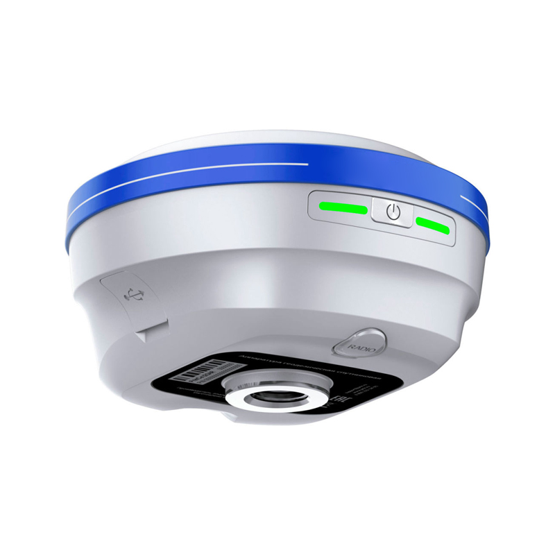
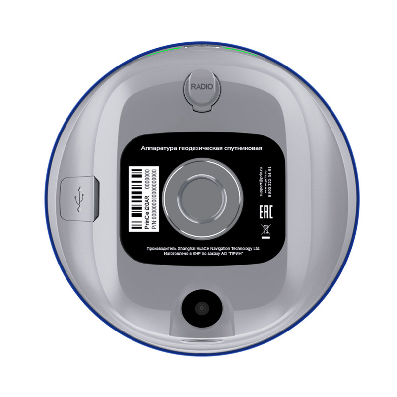
1.Features dual LED indicator lights and a single button for easy status checking and operation.
2.Supports PC/mobile web access for remote monitoring and management.
6.Advanced Features:
1.Supports OTA (Over-The-Air) remote receiver upgrades, allowing users to easily obtain the latest software versions and features.
2.Comes with a CORS account, enabling fixed positioning immediately upon startup, simplifying the measurement process.
Supports CHCNAV Cloud Services, providing automatic cloud backup for projects, function code sharing, and other intelligent services.
Practical Application
1.Surveying and Mapping:
1.The CHCNAV i76 RTK's high-precision positioning and rapid initialization make it an ideal choice for surveying and mapping applications. It can be used for topographic surveys, engineering surveys, cadastral surveys, and other tasks, improving measurement accuracy and efficiency.
2.Agricultural Applications:
1.In agriculture, the CHCNAV i76 RTK can be used for the development and application of agricultural machinery navigation and autonomous driving systems. By integrating with agricultural machinery, it enables precise operations in tillage, planting, management, and harvesting, improving agricultural production efficiency and quality.
3.Disaster Monitoring:
1.In disaster monitoring, the CHCNAV i76 RTK can be used for real-time monitoring and early warning of natural disasters such as geological disasters and flood disasters. By receiving global satellite positioning system information, it can record and analyze the real-time positions of monitoring points, detect abnormalities promptly, and issue warning signals.
4.Smart City Construction:
1.In smart city construction, the CHCNAV i76 RTK can be used for high-precision measurement and monitoring tasks in urban planning, municipal facility construction, traffic management, and other fields. It provides reliable data support for the construction and management of smart cities.
In summary, the CHCNAV i76 RTK, with its excellent performance and wide range of practical applications, holds significant value in surveying and mapping, agricultural applications, disaster monitoring, and smart city construction.
Logistics information


Logistics information
technical parameter
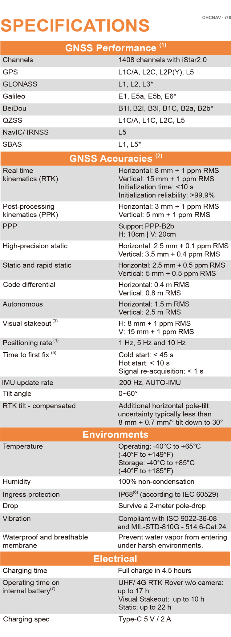
| GNSS Performance | Channels | 1408 channels with iStar2.0 |
| GPS | L1C, A, L2C, L2P(Y), L5 | |
| GLONASS | L1, L2, L3 | |
| Galileo | E1, E5a, E5b, E6* | |
| BeiDou | B1I, B2I, B3I, B1C, B2a, B2b | |
| QZSS | L1, L2, L5, L6* | |
| PPP | B2b-PPP | |
| SBAS (EGNOS Support) | L1, L5 | |
| GNSS Accuracies | Real time kinematic (RTK) | H: 8 mm + 1 ppm RMS |
| V: 15 mm + 1 ppm RMS | ||
| Initialization time: <10 s | ||
| Initialization reliability: >99.9% | ||
| Post-processing kinematic (PPK) | H: 3 mm + 1 ppm RMS V: 5 mm + 1 ppm RMS | |
| High-precision static | H: 2.5 mm + 0.1 ppm RMS V: 3.5 mm + 0.4 ppm RMS | |
| Static and rapid static | H: 2.5 mm + 0.5 ppm RMS V: 5 mm + 0.5 ppm RMS | |
| Code differential | H: 0.4 m RMS | V: 0.8 m RMS | |
| Autonomous | H:1.5 m RMS | V: 2.5 m RMS | |
| Visual survey | Typical 2~4 cm, range 2~15 m | |
| Positioning rate | 1 Hz, 5 Hz and 10 Hz | |
| Time to first fix | Cold start: < 45 s, Hot start: < 10 s Signal re-acquisition: < 1 s | |
| IMU update rate | 200 Hz | |
| Till angle | 0-60° | |
| RTK tilt-compensated | Additional horizontal pole-tilt uncertainty typically less than 8 mm + 0.7 mm/° tilt | |
| Environments | Temperature | Operating: -40°C to +65°C |
| (-40°F to +149°F) | ||
| Storage: -40°C to +85°C | ||
| (-40°F to +185°F) | ||
| Humidity | 100% non-condensation | |
| Ingress protection | IP68(6) (according to IEC 60529) | |
| Drop | Survive a 2-meter pole-drop | |
| Vibration | Compliant with ISO 9022-36-08 and MIL-STD-810G- 514.6-Cat.24. | |
| Waterproof and breathable membrane | Prevent water vapor from entering under harsh environments | |
| Electrical | Power consumption | UHF/ 4G RTK Rover w/o camera: |
| Typical 2.8 W | ||
| Visual Stakeout/Visual Survey: | ||
| Typical 4 W | ||
| Operating time on internal battery | UHF/ 4G RTK Rover w/o camera: | |
| up to 22h | ||
| Visual Stakeout/Visual Survey: | ||
| up to 17 h | ||
| UHF RTK Base: up | ||
| External power input | 9 V DC to 24 V DC | |
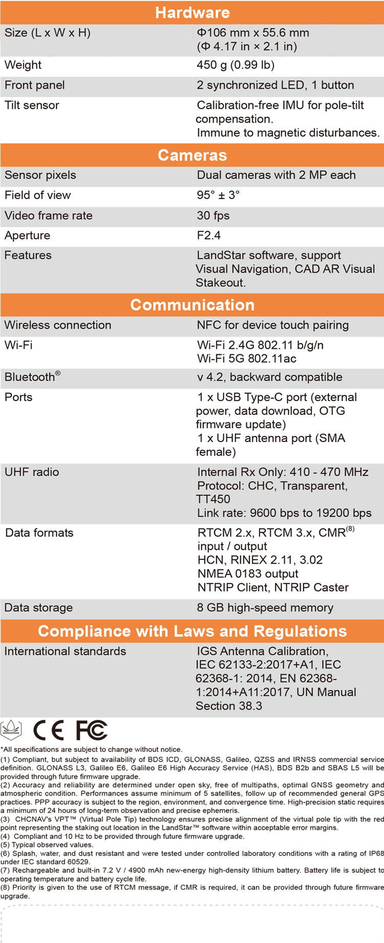
| Hardware | Size (D x H) | Φ106 mm x 55.6 mm (Φ 4.17 in × 2.1 in) |
| Weigh | 450 g (0.99 lb) | |
| Front pane | 1.1'' OLED Color Display | |
| 2 synchronized LED, 1 button | ||
| Tilt sensor | Calibration-free IMU for pole-tilt compensation. Immune to magnetic disturbances | |
| Cameras | Sensor pixels | Dual cameras with 2 MP each |
| Field of view | 95° ± 3° | |
| Video frame rate | 30 fps | |
| Aperture | F2.4 | |
| Features | LandStar software, support Visual Navigation, CAD AR Visual Stakeout | |
| Communication | SIM card type | Nano-SIM card |
| Network modem | Integrated 4G modem: TDD-LTE, FDD-LTE, WCDMA, EDGE, GPRS, GSM | |
| Wireless connection | NFC for device touch pairing | |
| Wi-F | Wi-Fi IEEE 802.11a/b/g/n/ac, access point mode | |
| Bluetooth | 5.0 and 4.2 +EDR, backward compatible | |
| Ports | 1 x 7-pin LEMO port (RS-232) 1 x USB Type-C port (external power, data download, firmware update) 1 x UHF antenna port (TNC female) | |
| Built-in UHF radio | Rx/Tx: 410 - 470 MHz Transmit Power: 0.5 W to 2 W Protocol: CHC, Transparent, TT450, Satel Link rate: 9 600 bps to 19 200 bps Range: Typical 3 km to 5 km, up to 15 km with optimal conditions | |
| Data formats | RTCM 2.x, RTCM 3.x, CMR input / output HCN, HRC, RINEX 2.11, 3.02 NMEA 0183 output NTRIP Client, NTRIP Caster | |
| Data storage | 32 GB internal memory. Support 128 GB external expansion |